 Route Editor

| Guide | ♦ | 8 Triplogs | 0 Topics |
details | drive | permit | forecast | route |
stats |
photos | triplogs | topics | location |
| 166 | 8 | 0 |
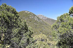
Steep and Steady by markthurman53   Overview OverviewThis is a 1.6-mile trail from Scotia Creek along the Sunnyside Canyon Road to a saddle between two peaks, Peterson and Lyle. No, this trail doesn’t go to Peterson Peak but I guess you could get there from this trail. This trail is a bit confusing because at the trailhead it is labeled as the Crest Trail #103. This is a continuation of the Crest Trail which ends up heading north another 3.1 miles to the Crest Road. The Peterson Trail is the first 1.6 miles of the Crest Trail up to the saddle between Lyle and Peterson Peak. Some maps Show the Peterson Trail as going all the way to the Huachuca Peak Trail. Either way, it is steep and the first part rocky. There are great views along the way of the greater Huachuca Mountains to the south and in a couple of spots Huachuca Peak. Hike The trailhead is along the Sunnyside forest service Road 4.7 miles in from the Montezuma Canyon Road, Fort Huachuca Gate 7 (not an entrance) is another 0.2 miles further in. The trail is posted alongside the road as the Crest Trail #103. The trail starts by dropping down into a creek bed. You just dropped down the better portion of the 38 feet total descent for this trail, the rest is up (1149 feet). This trail is deceiving because the first part is really rocky and in places, a bit hidden in the brush but the majority of the trail is well-groomed and easy to find and not rocky at all, just steep. Not much to say about this trail, it is one of those trails where you have to get from down here to up there and don’t want to waste any time. There are a few spots along the trail with views to the south overlooking Scotia Canyon and the greater Huachuca Mountains to the south. If you were to pick a natural division between the north and south Huachuca Mountains, It would be here; Scotia Canyon to the west and Garden Canyon to the east. From this trail that division seems obvious, separating Huachuca Peak from the higher peaks to the south and kind of a valley in between. At the saddle between these two peaks is where the Peterson trail ends but the Crest Trail continues along the ridge. For those references that show the Peterson Trail continuing to the Huachuca Trail, it is fairly level from here with a gradual drop to the saddle where it meets the Huachuca Peak Trail. From there the trail continues along the ridge as the Crest Trail. Nice views to the west and down Lyle Canyon from along the crest trail.
Check out the Official Route and Triplogs. Leave No Trace and +Add a Triplog after your hike to support this local community. One-Way Notice This hike is listed as One-Way. When hiking several trails on a single "hike", log it with a generic name that describes the hike. Then link the trails traveled, check out the example. | ||||||||||||||||||||||||||||||||||||||||||||||||||||||||||||||||||||||||||||||||||||||||||||||||||||||||||||||||||||||||||||||||||||||||||||||||||||||||||||||||||||||||||||||||


