 Route Editor

| Guide | ♦ | 11 Triplogs | 0 Topics |
details | drive | permit | forecast | 🔥 route |
stats |
photos | triplogs | topics | location |
| 121 | 11 | 0 |
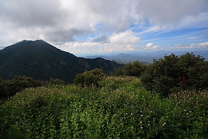
  Summary SummaryThis is one of the sweetest, tough little loops the Santa Ritas have to offer. Climb a super-steep trail, hit a gorgeous saddle, scramble out to a seldom visited peak to take in breathtaking views of Hopkins and Wrightson then top it off with a jaunt along one of the sweetest trails in Tucson before descending to an old mine. Sound good? Hike From the ever-present Roundup trailhead at the top of Madera Canyon head off from the top end along the Old Baldy trail. Within a quarter-mile, the Old Baldy trail breaks off left at a signed intersection. Continue straight ahead on up the Vault Mine trail, which has been written up before on this site. The trail first climbs up the east side of Madera Creek for a ways, then breaks away left through some wonderful forested areas. Look and listen for the elegant trogon through here, it seems to be a bit of a hotspot. After a total of 0.6 miles from the Baldy intersection, an old metal sign on your right announces the intersection for the Carrie Nation trail straight ahead and the Vault Mine trail which breaks off to the right. Head right and prepare to sweat...you're gonna gain over 1300 feet in the next 0.9 miles on perhaps the steepest trail in Tucson (hence the old nickname, Very Steep Trail). The Vault Mine trail crisscrosses up the ridge leading up to the Agua Caliente trail. It passes through some outstanding forest along the way and is pretty well-shaded. About halfway up the Santa Rita Crest and Ridgeline pops through the trees, always a wonderful sight. About 2/3 of the way up you'll pass the Treasure Vault mine on your right. After a total of roughly 1.8 miles from the trailhead, you'll come to the signed intersection for the Agua Caliente trail, at a little over 7200 feet and 1770 feet from your car.
From Bearpaw continue on the path as it continues to head west and climb up to 7390 through some dense foliage. The trail varies from easy to follow to quite vague but you are hiking a vegetated ridgeline so there are not that many places you can go. Climb more before descending to a second saddle where you can see Peak 7661 (Pete Mountain) right in front of you. This nameless saddle sits about 7164, so you gotta climb about 500 more feet up to Pete. The route becomes pretty vague through here, but there are intermittent cairns and anytime you wander off a brief search will likely turn up the route again. Like before, there really is nowhere else to go. After about 0.4 miles of scrambling and climbing you'll finally reach the cleared out, grassy summit of Pete Mountain (aka Santa Rita Peak). The views in all directions are just astounding. Especially out to Wrightson, the Crest, and Hopkins. There are amazing views south of Hopkins into the rugged Rattlesnake Canyon. There is a register here. The bushwhack/route traversing out to the summit of Pete is just a touch under 1 mile from the Agua Caliente Saddle. Head back the way you came to Agua Caliente Saddle. Head back east on the Agua Caliente trail to the Vault Mine Intersection. Continue past the Vault Mine, staying on Agua Caliente. The next 1.3 miles out to the unsigned but obvious Carrie Nation trail intersection take you along one of the sweetest stretches of trail in the Santa Ritas and Tucson in general. The elevation change is minimal. The views and vegetation along the way are maximal. Cross over many rockpiles and cross over a few drainages, cross through some flower fields and cross through some primo pine forest. About 1.3 miles from the Vault intersection you will see a clear, unmarked trail break off to your left and descend sharply down the canyon. This is the uppermost section of the Carrie Nation trail. If you hit the Josephine Saddle you went too far. Descend the steep upper reaches of the Carrie Nation trail as it descends among the pines down steep switchbacks to ultimately hit the canyon bottom, which descends more gradually down to the official End of Trail sign marking the upper limit of the maintained Carrie Nation trail. This continuation segment is just as easy to follow. Once you hit the canyon bottom from the Agua Caliente trail, follow it down to the End of Trail sign, cross over the little creek, and check out the Carrie Nation mine. A little farther down is the old machinery left behind. Keep going past the machinery and follow the Carrie Nation 0.6 miles back to the intersection for the Vault Mine trail at the old metal sign. There used to be a new wooden sign for the Carrie Nation trail here, the last two times I came through the sign was broken. Head back down the bottom reaches of Vault Mine to Madera creek and follow the trail back past the Old Baldy intersection, then your car to complete this 7.5 mile, 3000 foot gain beauty. Check out the Official Route and Triplogs. Leave No Trace and +Add a Triplog after your hike to support this local community. | |||||||||||||||||||||||||||||||||||||||||||||||||||||||||||||||||||||||||||||||||||||||||||||||||||||||||||||||||||||||||||||||||||||||||||||||||||||||||||||||||||||||||||||||||||||||||||||||||||||||


