 Route Editor

| Guide | ♦ | 5 Triplogs | 0 Topics |
details | drive | permit | forecast | route |
stats |
photos | triplogs | topics | location |
| 40 | 5 | 0 |
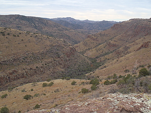
Scenic route to Powers Garden by jacobemerick  Overview OverviewThis trail starts at Mud Spring and provides a scenic hike into Powers Garden in the heart of the Galiuro Wilderness. There are plenty of other routes to reach the Garden, this one is relatively shaded and has less elevation difference, making it an intriguing summertime option. Hike To reach the start of this trail, first you need to hike to Mud Spring, which is easiest done by starting at Deer Creek Trailhead, taking East Divide Trail over a foothill, and then connecting with Tortilla Trail. There are signs along the way for "Mud Spring" to help with navigation. Sycamore Trail heads northwest from the spring area and is marked by a humble sign.
After passing a faint connector with Tortilla Trail, the trail levels out at 1.9 miles and you get an expansive view of Sycamore Creek below. The descent is no picnic, so this is a good spot to sit and relax for a minute. There is a set of switchbacks that quickly drop 600', and they've been re-routed a few times, so route-finding here may be challenging. The path clears up near the bottom. Once at the bottom, the trail follows the creek downstream via a defined tread, hopping from bank to bank. If the overgrowth ever gets too annoying, the creek itself is usually dry, so rock-hopping is also an option. There are long sections of shaded walking that are quite pleasant. At 4.3 miles the trail climbs up the east bank, breaking free of the trees, striding across the grassy hillside. It stays high on the bank, swinging down into a large drainage near Sycamore Canyon Spring before continuing on. On the far side of the spring, it begins to drop again, returning to the creek, and at 5 miles you are back at the bottom. The trail doesn't stay with the creek for long. It immediately hops over the west bank and makes a short climb up that side, making a shortcut through low brush over to Rattlesnake Canyon as it comes from the west. The confluence is one of the most iconic spots of the Galiuros and it may be worth a side trek for a good vantage. Anyways, after the short climb, the trail drops down to Rattlesnake Creek, almost petering out before ending at the relative highway of Powers Garden Trail. It's an easy few miles from here to Powers Garden. Water Sources Mud Spring is dependable, but being so close to the trailhead, it has limited usefulness. Sycamore Creek is seasonal at best, although both Sycamore Canyon Spring and Rattlesnake Creek (near the confluence) are dependable. Camping Sycamore Creek is very rocky and narrow, making this a difficult section to camp along. This trail is good for connecting to much better camping opportunities in the Gardens area. Check out the Official Route and Triplogs. Note This is a moderately difficult hike. Leave No Trace and +Add a Triplog after your hike to support this local community. One-Way Notice This hike is listed as One-Way. When hiking several trails on a single "hike", log it with a generic name that describes the hike. Then link the trails traveled, check out the example. | |||||||||||||||||||||||||||||||||||||||||||||||||||||||||||||||||||||||||||||||||||||||||


