Route Editor

| Guide | ♦ | 55 Triplogs | 6 Topics |
details | drive | permit | forecast | route |
stats |
photos | triplogs | topics | location |
| 761 | 55 | 6 |
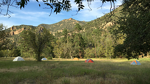
Backpack by whereveriroam   Terricita10 and I had wanted to make this trip to historic Powers Garden from the moment we heard about it. I had several concerns on making this trip, such as the lack of reliable water, vague trails, access issues, and that the Galiuro's where Powers Garden is located is out in the middle of nowhere; a true wilderness. Before we set out on this trip, we got whatever trail information that we could find, as well as; maps, GPS waypoints, useful info from HAZ member sredfield, and then waited for the right weather. I'm glad we found out all we could since the waypoints from wayhoo.com were way off, and the USGS 1996 topo map of the area has major flaws of the trail's locations. We were very fortunate on our timing for this trip after finding out from a local cowboy we met that in his 14 years of punching cattle in this area, he never saw the watercourses flowing the way they were in this typically dry range. We came a few days after a 2-week on and off again wet pattern, which deposited a good amount of snow on this range. The day before we came, it warmed up into the 70-80 degree range and would stay like that on our 2-day trip, thus melting almost all the snow. Terricita10 and I had wanted to make this trip to historic Powers Garden from the moment we heard about it. I had several concerns on making this trip, such as the lack of reliable water, vague trails, access issues, and that the Galiuro's where Powers Garden is located is out in the middle of nowhere; a true wilderness. Before we set out on this trip, we got whatever trail information that we could find, as well as; maps, GPS waypoints, useful info from HAZ member sredfield, and then waited for the right weather. I'm glad we found out all we could since the waypoints from wayhoo.com were way off, and the USGS 1996 topo map of the area has major flaws of the trail's locations. We were very fortunate on our timing for this trip after finding out from a local cowboy we met that in his 14 years of punching cattle in this area, he never saw the watercourses flowing the way they were in this typically dry range. We came a few days after a 2-week on and off again wet pattern, which deposited a good amount of snow on this range. The day before we came, it warmed up into the 70-80 degree range and would stay like that on our 2-day trip, thus melting almost all the snow.Before I get into this trip description, I think I should write some things about this trip. For starters, it's remote, and don't count on getting any help if needed quickly. This trip is not for day hikers unless you are a real strong hiker who is experienced at route finding since the trails in this wilderness are confusing at times, with many cattle trails intersecting them. Although it's only a 21'elevation difference between the TH where we started and Powers Garden, you must climb up to a saddle, drop into Sycamore Canyon, climb out to another saddle, then drop into Horse Canyon, which will tie you into Rattlesnake Canyon. There are several ups and downs along the way for a total elevation gain of about 2300' 1 way. Lastly, don't rely on finding water. We found many bones on this trip telling us how hot and dry it gets in this area.
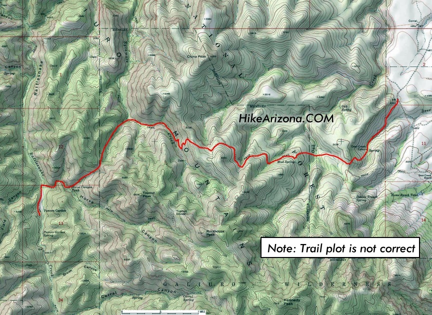
We planned to hike the whole way in on the Tortilla Trail #254 all the way down to the Powers Garden #96 Trail. These 2 trails intersect about a 1/4 of a mile north of Powers Garden. Instead, since we were treated to a babbling brook next to the East Divide Trailhead that leads up into the rolling hills, these rolling hills, in turn, overlook the tree-lined brook, we decided after consulting our map and finding out that these 2 trails will intersect one another that it would be our route. There's a gate next to the brook, the 1st of 5, that we had to open and CLOSE on this trip. It was signed stating that there was no water to be found at Powers Garden. From the sight of the flowing brook and all the snow on the Galiuro's melting away in the warm sunshine, we felt pretty sure that sign would need to be updated on our return. It is important to close these cattle gates since the cattle are allowed to graze in the wilderness. From my understanding and signs posted on FR 253, the ranchers allow access to the TH's into the Galiuro's on roads that run thru their properties. If they want to and have done in the past around this wilderness, the ranchers construct gates and lock them to keep people out. So please don't piss off the ranchers. Thru the gate, we immediately encountered our 1st of 37 water crossings. Once across the brook, you'll stay on the southern side of the tree-lined brook hiking up thru the rolling grassland hills that are dotted with scrub oak. You will then have to descend back into the brook and cross onto the north slope. You'll then have to hike all the way up the north slope to a fence line and head north along this fence line to a 2nd gate at a large saddle. At this gate, the Tortilla Trail intersects the trail you're on coming in from the NE. Up to this point, you've gone about 1.25 miles and have wonderful views of the above-mentioned ranges as well as the Galiuro's Kennedy Peak just to your south. From the saddle, after passing thru the gate on the well-defined trail, continue westward for about 1/2 a mile, descending gradually to the 2 fork crossing of Oak Creek. Just west of the double-crossing on your climb out of Oak Creek, there is a trail JCT. The faint left branch marked by cairns is the continuation of the E. Divide trail. You'll want to take the right fork. Strangely this is marked Sycamore Trail #278. Don't ask me what happened to the Tortilla Trail here but continue west and up on this trail. After a short time, you'll encounter a water tank that you're tempted to think is Mud Spring, which it's not. This area is the worst with cattle trails, and care must be taken in choosing the right route. Stay about 150' to the south of the tank and continue heading west, and you should find the trail. A few minutes after this tank, you will come to another trail intersection by a corral. This is Mud spring, and the spring is located behind the corral uphill a little bit. To this point, you've gone about 2 miles from your vehicle, and this is the Tortilla trail/Sycamore trail intersection, take the left trail (south), which is the Tortilla. After about 2-5 minutes hiking thru level grazing pastures, you will see a faint trail branching to your right marked by cairns. Take this branch. It's tempting not to since you're on a real good definable trail. We did and had to backtrack, losing 1/2 hours after meeting up again with the E. Divide trail. From this faint JCT, you'll suffer for the next mile+ climbing a rocky ridge to a saddle, which is the entrance to Sycamore Canyon. Before this saddle, you will get your last views of the Pinaleno's, and you will have to pass thru either 1 or 2 cowboy fences. This saddle is about 1.25 miles from Mud Spring. At this saddle, you will start your descent into Sycamore Canyon rather quickly. Just before reaching the creek at about 1/4 mile below the saddle, you will come to another trail sign, your last for a while. On our topo, this has to be the spot where the old Tortilla trail branches off faintly from the SE around the creek's headwaters. The Sycamore trail from earlier comes in from the NW or right side of the creek. Our trail or new Tortilla will head down to the left side of the heavily wooded creek. You'll continue down Sycamore Canyon crossing it numerous times for about a mile before reaching what is called Upper Sycamore Tank, this was not identified on our topo. The tank is painted woodland camo and out of order. Once passing the tank, you will gradually climb away from the creek on its SW side. Impressive views open to the north of the Santa Theresa's once again and down Sycamore Canyon. High on the NE side of Sycamore Canyon are some really cool-looking red stone cliffs, and if you look back down to the creek, you can see parts of the Sycamore trail. As you hike up and away from the creek, the vegetation changes to a desert variety with the likes of agave, prickly pear, manzanita, etc... This stretch will last about 2 miles with a bunch of ups and downs on your way to Horse Pass, and you basically contour around the SW side of the canyon, passing around 2 good-sized feeder drainages that were pouring small waterfalls when we made our trip. Before reaching Horse Pass, you will come across either 1 or 2 more cowboy fences. If you have a topo in which you should for this trip, the pass is located between Peak 6394 to the NW and Topout Peak to the SE. At Horse Pass, your view will change, and you will be able to look down into heavily pine tree-lined; Horse Canyon, Rattlesnake Canyon and the Western Mountain Divide of the Galiuro's. A note here is I saw no evidence of bark beetle damage. Although you can figure out where you want to go to reach Powers Garden, you still got 2 miles with an elevation drop of 1100' to go to reach Rattlesnake Creek. I'd say 1/2 of that is accomplished via rocky switchbacks, but after 5 hours with a pack on, they hurt (We found the switchbacks weren't too bad on the way out). At the bottom of the switchbacks, you'll be in Horse Canyon with about a mile to go. On the way out, we found a downed trail sign at a faint intersection, just a little above where the trail leaves the creek. We figured that the faint trail continuing up the creek was the other side of the old Tortilla trail. Our hike down Horse Canyon was wild, with 10 creek crossings to negotiate. With some of these, we had to toss big rocks into to act as stepping-stones, and with the others, we rock hopped! I was really impressed by how weird a place this is, you have lots of pine trees in the canyons but scrub oak and desert vegetation at the higher elevations. As we approached Rattlesnake Creek, we came upon 2 more cowboy fences with no gates and the ever-increasing sound of Rattlesnake Creek. When we reached the creek, we realized we forgot to bring a raft. I'm not kidding; we couldn't cross the creek safely. Instead, we headed south up the river and were able to find a large downed pine tree, which spanned the river. I'd say the river was only 50' wide, but it's a rush with all that volume flowing below you. I won't get into what's at Powers Garden, so you can be as surprised as we were. I must say it's well worth the trip, and I plan on doing this again and again. Gate Policy: If a gate is closed upon arrival, leave it closed after you go through. If it is open, leave it open. Leaving a closed gate open may put cattle in danger. Closing an open gate may cut them off from water. Please be respectful, leave gates as found. The exception is signage on the gate directing you otherwise.
Check out the Official Route and Triplogs. Leave No Trace and +Add a Triplog after your hike to support this local community. | ||||||||||||||||||||||||||||||||||||||||||||||||||||||||||||||||||||||||||||||||||||||||||||||||||||||||||||||||||||||||||||||||||||||||||||||||||||||||||||||||||||||||||||||||||||||||||||||||||||||||||