 Route Editor

| Guide | ♦ | 30 Triplogs | 2 Topics |
details | drive | permit | forecast | route |
stats |
photos | triplogs | topics | location |
| 477 | 30 | 2 |
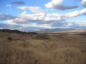
  Tortilla Trail leads from the grasslands that spread along the eastern slopes of the Galiuros to the heart of that remote mountain range in deep, wide Rattlesnake Canyon. From the trailhead at Deer Creek, it meanders among shallow canyons and rocky flats in the shadow of the bluffy slopes that characterize the Galiuros. Most of this trail is in open country, where isolated oaks and grassy flats do little to restrict the far-reaching views of rugged canyons, rocky escarpments, and distant mountains. You may see evidence of mountain lion along this trail. These reclusive animals are about as plentiful here as they get in the southwest. There are mule deer and black bears in the area and smaller animals, including shrill-voiced rock squirrels and colorful scarlet kingsnakes. Typical vegetation in the open areas includes bear grass, sotol, cane cholla, and manzanita. You'll find Arizona walnut, Netleaf Oak, and Silverleaf Oak down in the canyons, among others. Tortilla Trail leads from the grasslands that spread along the eastern slopes of the Galiuros to the heart of that remote mountain range in deep, wide Rattlesnake Canyon. From the trailhead at Deer Creek, it meanders among shallow canyons and rocky flats in the shadow of the bluffy slopes that characterize the Galiuros. Most of this trail is in open country, where isolated oaks and grassy flats do little to restrict the far-reaching views of rugged canyons, rocky escarpments, and distant mountains. You may see evidence of mountain lion along this trail. These reclusive animals are about as plentiful here as they get in the southwest. There are mule deer and black bears in the area and smaller animals, including shrill-voiced rock squirrels and colorful scarlet kingsnakes. Typical vegetation in the open areas includes bear grass, sotol, cane cholla, and manzanita. You'll find Arizona walnut, Netleaf Oak, and Silverleaf Oak down in the canyons, among others.At Mud Spring, Sycamore Canyon Trail #278 branches off to the north. The Tortilla Trail then drops into the upper reaches of Sycamore Canyon before climbing to a saddle at the top of a steep descent that leads into Horse Canyon and eventually into Rattlesnake Canyon. Rattlesnake is one of two main drainages that split the Galiuros, and the other is Redfield Canyon. At the bottom of Rattlesnake Canyon, you'll find Powers Garden and the Powers Garden Trail #96, both named after a family whose members once mined gold in this area and were principals in a famous shootout that occurred at Power Cabin. This trail can be difficult to locate in a few places, and it is crisscrossed by several ranch and cattle trails that can confuse the issue even more. If you look around a bit, however, you can generally relocate the trail without much trouble. While it is always advisable to take a topographic map and a compass on a trip into the backcountry, it is essential in the Galiuros!
Check out the Official Route and Triplogs. Leave No Trace and +Add a Triplog after your hike to support this local community. One-Way Notice This hike is listed as One-Way. When hiking several trails on a single "hike", log it with a generic name that describes the hike. Then link the trails traveled, check out the example. | ||||||||||||||||||||||||||||||||||||||||||||||||||||||||||||||||||||||||||||||||||||||||||||||||||||||||||||||||||||||||||||||||||||||||||||||||||||||||||||||||||||||||||||||||||||


