 Route Editor

| Guide | ♦ | 30 Triplogs | 0 Topics |
details | drive | no permit | forecast | route |
stats |
photos | triplogs | topics | location |
| 37 | 30 | 0 |
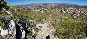
400 foot ascent with a little bite by joebartels  Overview OverviewLike Peak 2429 to the south this is not designated. It is heavily used and neither after 24 years in my travels have been signed stay out. Obey official signage if the status changes. There are two official trails at Shadow Mountain. Big Loop Trail #310 & Small Loop Trail #312. There is no designated parking or trailhead. Hike Ascends gently to a water fountain. Do not count on the fountain as a source of water. The grade increases as you pass a house in the neighborhood directly left. Tread is loose and crumbly but travels well. Excellent views of the distant McDowell Mountains open up to the East. Lookout Mountain stands proud just over a mile WNW.
Creosote bushes, brittlebush & short stubby Palos Verdes dominate the landscape. Lots of Globe Chamomile and an African Daisy on my 2020 March hike, both are considered invasive. Roughly half of this hike utilizes Big Loop Trail #310. Junctions are unsigned. The ascent gets a bit steeper, and the footing gets a little looser. Not bad if you pay attention. A saddle opens up to the west, and you can see the towers on top of North Mountain. Then you reach a knob. The route up Shaw Butte is apparent to your right. It dips down before an aggressive ascent. It gets steep when it feels like the final 100 feet to go. Then it gets steeper. Exposed rock makes the footing good, so it's easier. Descending might require a handhold or two. The top is a jagged slab ridgeline with several places to take a comfortable break in nice weather. The summit has been tagged more than an Instagram photo begging to be liked. As of this writing, the majority has been painted over. Admire Piestewa before heading back down. If you followed the trail to the summit, heading back on the ridgeline has a little better footing for about 50 feet east/down. Enjoy. Check out the Official Route and Triplogs. Leave No Trace and +Add a Triplog after your hike to support this local community. One-Way Notice This hike is listed as One-Way. When hiking several trails on a single "hike", log it with a generic name that describes the hike. Then link the trails traveled, check out the example. | |||||||||||||||||||||||||||||||||||||||||||||||||||||||||||||||||||||||||||||||||||||||||||||||||||||||||||||||||||||||||||||||||||||||||||||||||||||


