Route Editor

| Guide | ♦ | 14 Triplogs | 0 Topics |
details | drive | permit | forecast | route |
stats |
photos | triplogs | topics | location |
| 62 | 14 | 0 |
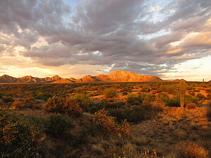
Easy trail with panoramic views by azdesertfather  This loop is one of a few you can take in McDowell Mountain Regional Park. It is pretty exposed, so not a great choice in the summer. This loop is one of a few you can take in McDowell Mountain Regional Park. It is pretty exposed, so not a great choice in the summer.History The park was created in 1964 and later expanded into 21,099 acres, with scenic mountain views all around. A 360-degree view along the trail presents the Mazatzals, Mt. Ord, and Four Peaks to the north and east, Red Mountain and the Superstitions to the south and east, and Thompson Peak and the rest of the McDowell range to the west.
Overview This loop one can do as a full or a lasso loop, at virtually the same distance. A lasso loop starts and ends along Wagner from the Wagner Trailhead. A full loop requires a little bit of pavement walking at the beginning or end, between Wagner Trailhead and Bluff Trailhead along Palisades Way. I did this trail clockwise as a full loop from Wagner Trailhead, where non-campers in this area are encouraged to park. Hike After hiking a bit of pavement and passing a couple of bathrooms in the campground, I picked up Bluff Trailhead, crossed the Stoneman Wash Trail (named after the first military commander of the Arizona Territory), and climbed up onto a butte that offered great panoramic views. From there along much of the rest of the trail one can see the big fountain in Fountain Hills, which typically runs from the top of each hour for 15 minutes. Granite Trail is off to the right 1 mile from Bluff Trailhead and heads north. At the farthest point of the loop, a rock boulder area comes into view just outside the loop, which can make a nice, quick detour. After about 1.2 miles the trail crosses Stoneman Wash Trail again, quickly followed by a connection to Delsie Trail. At Delsie, veer to the right to stay on Granite. After another 0.6 miles is the junction with Wagner. Take Wagner for 1.1 miles to finish making it a full loop and return to Wagner Trailhead. For those wanting to make this a bit more of a hike, there are lots of options. About 3.6 miles from the Bluff/Granite trails intersection is Marcus Landslide; continue on Bluff for 1.2 miles, go left on Pemberton for 0.3 miles and right on Rock Knob to get to the turnoff for the landslide, or continue to the trail up to Tom’s Thumb. Both of these are on the McDowell-Sonoran Preserve, as well as further to the south, access to Thompson Peak.
Check out the Official Route and Triplogs. Leave No Trace and +Add a Triplog after your hike to support this local community. | ||||||||||||||||||||||||||||||||||||||||||||||||||||||||||||||||||||||||||||||||||||||||||||||||||||