 Route Editor

| Guide | ♦ | 10 Triplogs | 0 Topics |
details | drive | no permit | forecast | map |
stats |
photos | triplogs | topics | location |
| 51 | 10 | 0 |
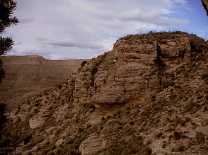
It's -A- Standout! by imike  It is accessed by leaving the "A" Trail between the 6200'-6400' levels, walking north a few hundred yards over to the obvious rock projection. Approached from the lower reaches it towers hundreds of feet above you. Accessed from the top, it juts out as a rocky cut, separated from the ridge by a narrow cleft.
There are broad meadow areas surrounding the Bluffs, providing a variety of possible camping spots. If you'd like something a bit more home like... check out the narrow clefts on the east side of the Bluffs. You may discover the entry to some interesting cave formations that could provide protection from the elements. One of those caves will carry you all the way through the Bluffs to emerge on the west side on a small shelf, a hundred feet above the meadow below; quite the patio! The Bluffs also mark the traversing route to access the "A" Trail from the upper reaches of Ortega Canyon North, Yubao's Cut, Ortega Canyon South, Ortega Ridge, Jim's Cut and points beyond. This route, Michal's Traverse, is slowly being developed into a trail as the popularity and use continue to increase. The Bluffs also serve to give notice of the approach of the most interesting feature on the "A" Trail: Leah's Lair, the Fissure. It lies just above the Bluffs. It is easy to bypass unless you make note of it's proximity to the huge Bluffs formation. Note: recently lower cave openings have been discovered in the bottom of Leah's Lair... if you have hiked up to the Bluffs to experience the caves, you may want to go a bit higher up the trail to explore the more dramatic formations to be found there. So... for a destination... or for the connecting potentials. The Bluffs have much to offer! Note: if exploring the caving potentials: be very careful... go prepared! Check out the Triplogs. Leave No Trace and +Add a Triplog after your hike to support this local community. One-Way Notice This hike is listed as One-Way. When hiking several trails on a single "hike", log it with a generic name that describes the hike. Then link the trails traveled, check out the example. | ||||||||||||||||||||||||||||||||||||||||||||||||||||||||||||||||||||||||||||||||||||||||||


