Why not make Blacketts Ridge harder?! by Jeffshadows
Background
On 31 July 2006, Sabino Canyon experienced a massive flood event. The result was the devastation of the infrastructure and many of the recreation sites. The floodwaters and slides that resulted also heavily damaged many of the hiking trails in Sabino, closing some for over a year. This minor link trail is once such trail that has recently (Fall 2008) been entirely restored by the Forest Service.
Hike
Follow the paved course of Sabino road to the first tram stop. Just beyond the tram stop, a trail descends steeply into Sabino creek below. Follow this trail and cross the stream at a convenient place. Just across the creek, the Dam trail will be encountered, turn left take up its course for a 2/10ths of a mile walk northeast to the signed junction with the Link trail. Alternatively, follow the Dam trail from the Bear Canyon trailhead at the parking lot and avoid the road altogether.
The Link trail begins to climb immediately. The entire course of its travel is an ascent of the north canyon wall below the Saddle-back (Blackett's Ridge). It switchbacks continuously to gain roughly 900' of elevation by the time it connects with the Phoneline Trail #27. After about a half-dozen switchbacks, the trail encounters a signed junction with a side trail departing up-canyon to a series of picnic sites. The switchbacks continue, and the view of Sabino below becomes even more dazzling. At the end of a long switchback roughly 1/2-mile in, a small, improved vista is encountered. There is a large boulder facilitating a place to sit and take in unobstructed views of the entire canyon and the Front Range of the Catalinas. After leaving the vista, the trail rounds a dozen or more switchbacks and turns sharply into a junction with the Phoneline Trail #27.
When hiking several trails on a single "hike", log it with a generic name that describes the hike. Then link the trails traveled, check out the example.
WARNING! Hiking and outdoor related sports can be dangerous. Be responsible and prepare for the trip. Study the area you are entering and plan accordingly. Dress for the current and unexpected weather changes. Take plenty of water. Never go alone. Make an itinerary with your plan(s), route(s), destination(s) and expected return time. Give your itinerary to trusted family and/or friends.
Four specific day-use areas require a Coronado Recreational Pass or a National Pass/America the Beautiful Pass.
1) Sabino Canyon - located on the Santa Catalina Ranger District (520)749-8700
2) Madera Canyon - located on the Nogales Ranger District (520)281-2296
3) Cave Creek - located on the Douglas Ranger District (520)364-3468
4) Mt. Lemmon at 11 day-use sites.
2025Catalina State Park
Per vehicle (1 person): $10.00
Per vehicle (2-4 people): $20.00
Individual/bicycle: $5.00
 Route Editor

 Background
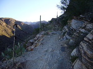


