 Route Editor

| Guide | ♦ | 64 Triplogs | 0 Topics |
details | drive | no permit | forecast | route |
stats |
photos | triplogs | topics | location |
| 620 | 64 | 0 |
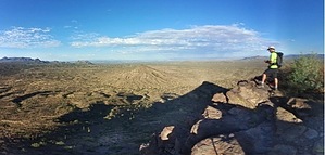
A shot of hiking espresso by neilends  Overview OverviewClimbing Brown's Mountain is kind of like drinking a shot of espresso: after a pretty short 1.6-mile hike, your trail reward is an explosion of expansive views from a lovely little cliff. If you're trying to get a mountain view without leaving the Phoenix metro area and without the longer (and annoyingly crowded) effort of Piestewa, Camelback, or Tom's Thumb, this is your spot. Warning Textbook desert hike. Bring ample water and be educated about hot weather hiking.
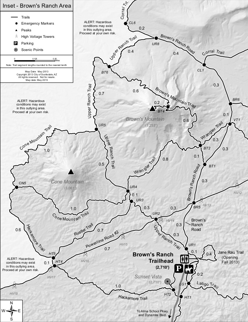
I think the trail names are a little confusing here, so here are a few words on that. The trail known as "Brown's Mountain Trail" doesn't start until you've hiked about 0.6 miles on another trail, called Brown's Ranch Road. Study the official McDowell-Sonoran Preserve map if you're at all confused. If you don't take the required, left turn at 0.6 miles, you will continue onto Brown's Ranch Road and do a partial circumference of the mountain. I don't know why MSP decided to call this a "road", but it is definitely a trail. Hike The trail to the summit starts at the clearly-marked and paved Brown's Ranch Trailhead. For about 0.6 miles, you will walk down the flat and easy "Brown's Ranch Road" trail. This northern section of the MSP is popular with mountain bikers, so you'll be passed by plenty of them on this stretch. This is a popular walking trail for area residents, so expect some crowds in nice weather. At 0.6 miles, there's an official sign pointing you to your left to reach the summit of Brown's Mountain. This is where Brown's Mountain Trail begins. What's fun about this mountain is that, both from the trailhead and from this 0.6-mile marker, you can look up and directly see your objective. The cliff-like summit might look daunting to a novice hiker or someone not in great shape. But this is one of the easiest mountain climbs in the metro area. For another 0.7 miles, you gradually make a few easy switchbacks up the mountainside. After that 0.7 miles, there's a sign giving you two options: to your right is a scenic overlook, and to the left is the summit. If you're not up for the 0.2-mile scramble to the summit but still want a nice view, the overlook is lovely and a good place for photos. The summit trail to the left features some loose footing, so hike it with care. My wife has a physiological fear of heights (dizziness, loss of balance), so she needed some hand-holding and cheerleading to make it up, but she was successful and can't wait to do it again. If you reach it, this summit is one of my favorites in town, despite the ease of reaching it. Be careful near the cliff edges. The 360 views are expansive. On a clear day you can see the Four Peaks and Battleship Mountain in the Superstitions, Camelback Mountain, Piestewa Peak, the South Mountain range, and many others. You can also see the parking lot that you walked in from. The views of the Preserve itself are also delicious. Brown's Ranch was an active ranch for decades, and most of the ranch buildings were at the foot of this mountain. In 1959, many ranch hands evidently scrambled up this mountain to lay some foundation for a structure and carved their names into a small concrete pad at the top. You'll know the year because one of them carved "1959" next to his name. If you skip the summit trail altogether or want to continue on Brown's Mountain Trail, you can continue until connecting with the Upper Ranch Trail. Water Sources Water fountains for both humans and dogs are at the trailhead. Camping Banned.
Check out the Official Route and Triplogs. Leave No Trace and +Add a Triplog after your hike to support this local community. | ||||||||||||||||||||||||||||||||||||||||||||||||||||||||||||||||||||||||||||||||||||||||||||||||||||||||||||||||||||||||||||||||||||||||||||||||||||||||||||||||||||||||||||||||||||||||||||


