 Route Editor

| Guide | ♦ | 7 Triplogs | 0 Topics |
details | drive | permit | forecast | map |
stats |
photos | triplogs | topics | location |
| 15 | 7 | 0 |
 The Pinal County Highpoint is located on the northern slope of Rice Peak. The Pinal County Highpoint is located on the northern slope of Rice Peak.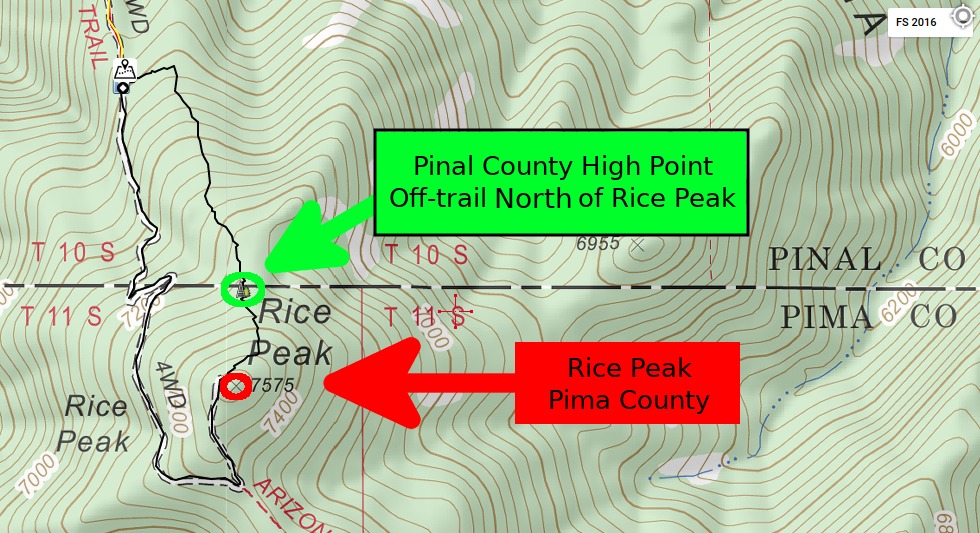 A large cairn and register exist in a small clearing surrounded by fire-damaged tree trunks. The easiest access is by leaving AZT #12 - Oracle Ridge to summit Rice Peak, before dropping about 275 feet in elevation to the Pima/Pinal boundary about 200 yards to the north. Remnants of an old road cut can be found just east of the county high point cairn and can be followed steeply down the ridge for half a mile to its end at FR 4475 (steeply dropping 750 feet over that distance). Hiking the AZT (also FR 4483 here) will cross the county line just over 100 feet lower than the high point on the ridge 200 yards to the east. Making the traverse between the two is not recommended due to very thick vegetation. Access is easiest either from Rice Peak above or from FR 4475 below.
Check out the Triplogs. Leave No Trace and +Add a Triplog after your hike to support this local community. One-Way Notice This hike is listed as One-Way. When hiking several trails on a single "hike", log it with a generic name that describes the hike. Then link the trails traveled, check out the example. | |||||||||||||||||||||||||||||||||||||||||||||||||||||||


