username
X
password
register
for free!
help
 This is likely a great time to hike this trail!  Check out "Preferred" months below, keep in mind this is an estimate. 
   🔥

Rice Peak, AZ

Guide 16 Triplogs  1 Topic
  3 of 5  
Fav
Wish
3
details
drive
permit
forecast
🔥
route  
stats
photos
triplogs
topic
location
117 16 1
Statistics
tap row or icons for details
Difficulty 4.5 of 5
Route Finding 1 of 5
Distance One Way 8.8 miles
Trailhead Elevation 7,290 feet
Elevation Gain 3,131 feet
Accumulated Gain 3,951 feet
Kokopelli Seeds 21.97
 Interest Peak
Photos Viewed All MineFollowing
Will recalculate on button tap!
9  2022-06-08 Jim
25  2020-02-20
Rice Peak - Pinal Co Hi Point - Silly Mtn
DixieFlyer
4  2018-03-10 FOTG
21  2018-02-18
Oracle Ridge Trail #1
DarthStiller
15  2016-04-26
Pinal County Highpoint
chumley
15  2012-03-31
Oracle Ridge - AZT #12
The_Eagle
18  2012-03-31
Oracle Ridge - AZT #12
Tortoise_Hiker
10  2012-03-31
Oracle Ridge - AZT #12
azdesertfather
Author
author avatar Guides 16,843
Routes 17,472
Photos 24
Trips 1 map ( 6 miles )
Age 28 Male Gender
Location HAZ, TrailDEX
Associated Areas
list map done
Tucson Region
Historical Weather
Trailhead Forecast
Radar Map
Expand Map
Preferred Jul, Jun, Aug, Sep
Sun  6:00am - 6:44pm
Official Route & 4 Rts
 
5 Alternative
 
Historic Fire Perimetersacres
🔥 2020 Bighorn Fire119.5k
🔥 2003 Aspen Fire87.7 mi*
🔥 2002 Oracle Hill16.3 mi*
🔥 View (All) - over Official Route 🔥
*perimeter length in miles


 Likely In-Season! 
Rice Peak is a prominent bump along Oracle Ridge and the gateway to the easiest access to the Pinal County High Point.
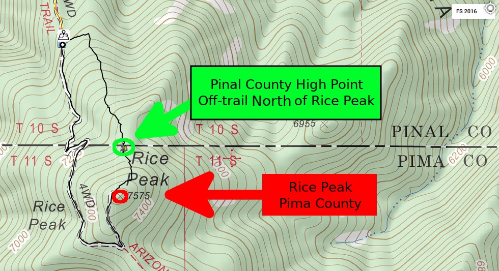

NOT Pinal County High Point, see link above.
remove free decal offer
It can be accessed by driving a very difficult jeep trail from the Peppersauce Campground or it can be reached on foot from the same point, other spots along the jeep route, or from AZT#12.

Gate Policy: If a gate is closed upon arrival, leave it closed after you go through. If it is open, leave it open. Leaving a closed gate open may put cattle in danger. Closing an open gate may cut them off from water. Please be respectful, leave gates as found. The exception is signage on the gate directing you otherwise.

2018-07-14 HAZ_Hikebot


    Check out the Official Route and Triplogs.

    Note
    This is a more difficult hike. It would be unwise to attempt this without prior experience hiking.
    Leave No Trace and +Add a Triplog after your hike to support this local community.

    One-Way Notice
    This hike is listed as One-Way.

    When hiking several trails on a single "hike", log it with a generic name that describes the hike. Then link the trails traveled, check out the example.
    WARNING! Hiking and outdoor related sports can be dangerous. Be responsible and prepare for the trip. Study the area you are entering and plan accordingly. Dress for the current and unexpected weather changes. Take plenty of water. Never go alone. Make an itinerary with your plan(s), route(s), destination(s) and expected return time. Give your itinerary to trusted family and/or friends.

     Permit $$
    no fees or permits reported

    if incorrect tell us about it

    Coronado Forest
    MVUMs are rarely necessary to review unless mentioned in the description or directions
    Coronado Motor Vehicle Use Maps (MVUMs)


     Directions
    or
     Road


    To hike
    page created by joebartels on Jul 10 2010 3:57 pm
     90+° 8am - 6pm kills
    helpcorrectionissue

    end of page marker