Route Editor

| Guide | ♦ | 7 Triplogs | 0 Topics |
details | drive | permit | forecast | route |
stats |
photos | triplogs | topics | location |
| 88 | 7 | 0 |
A Scramble to Remember by rvcarter  Overview OverviewFor an overview of Elephant Head, it’s hard to beat fricknaley’s description for the hike/climb from the south. “There are some famous peaks in the Santa Ritas, south of Tucson...Wrightson, Hopkins. None have the mystique of Elephant Head. The almost impossibly steep monolith crashing out of the western Santa Ritas into the desert seems to defy logic. Was this a place of sacrifice or violent deaths? Nobody knows for sure. But with old names including Picacho del Diablo and Cerro de Los Muertos, one must wonder.” Once on top, Elephant Head offers excellent views of the Santa Ritas and points south and features a unique collection of elephant-related objects-de-art that each visitor is supposed to add to. So take something to contribute and (supposedly) you will have good luck. Most Santa Ritas visitors flock to Madera Canyon, but it is a special treat to summit this fantastic rock formation. However, it takes a little work to get there from the south and a lot of work from the north. Background Not much information can be found on the ascent of Elephant Head from the north. I doubt many people have even tried it, given its daunting appearance. But, there is a triplog on HAZ describing a successful climb by bknorby and a small group that calls itself the Baja Arizona Hikers. They do a good bit of adventurous stuff, so I was intrigued when I saw her triplog and recruited my little group to do the same.
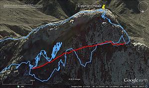
Hike/Climb The real fun starts after reaching the little saddle at about 4860 feet elevation (31.7253 N, -110.9353 W, WGS 84). It doesn’t seem possible to access the shelf you need to follow up from any other point. Getting to this starting point is a chore in and of itself. We tried going up one way and coming down another. Even though longer, I recommend the route we took up, since the route finding and scrambling are easier (you’ll have plenty of scrambling later on). On the way up, you pass through one of the densest Ocotillo forests that I’ve ever seen. Keep heading toward the arm that leads up to the saddle. As you get closer to the saddle, the gash you will be scrambling up becomes more visible …. and scarier. A few references have called this the Staley Peterson Route, but I could not find much about it on the internet. I included several overview pictures with my track on Google Earth to help someone get a feel for the route. However, once you leave the saddle, there won’t be many places to get off track. As my track shows, we made a mistake when we tried for the upper shelf too soon, had to retreat and work around some boulders to get back on track. The route gets narrow at a few points as you go up the ramp. Note that my track wanders a bit; this is because the route hugs the north face like flies on a (fill in your visual), and my GPS lost satellites frequently. I cleaned up my track a fair bit and added a red line, which I think approximates the route we took. Ignore the big jags across contour lines, which are noise. The route is continually up and across the face. Afterward, when you look at your pictures, it will be obvious where you went and why. When we visited, there was little in the way of cairns or trail to follow, except there were soil and vegetation disturbance in places. Once you reach the “nose” of the elephant’s head, you turn sharply left and scramble up the notch to the top. This is easier said than since some of the moves here are the most difficult of all, and the exposure is nothing to sneeze at. Keep heading up, and just before the top out, you’ll reach what might be the most challenging move of all. This is where a short rope may come in handy for all but the most fearless solo climber. The team may wish to be in position to catch the lead person. The leader can then “belay” the others up. However, one does not need any technical climbing equipment to reach the top, except a rope for this one spot. As bknorby said in her triplog: “At the top, we rejoiced in feeling alive!!! Nothing like some adrenaline coursing through the veins to make you live in the moment and enjoy the sense of accomplishment.” I can say it no better. You’re pretty spun up after summiting. We did not wish to return the same way, so we descended to the southeast saddle, along the route people typically follow on the hike from the south. At the saddle, we cut down to the little “starter” saddle mentioned earlier and returned to our vehicle. Caution This hike/climb is not technical but is challenging and offers some world-class exposure. No technical gear is needed, but a 20-foot rope will help some at a few places, especially the aforementioned top pitch. Hikers will need to make sure their footing and handholds are safe. This is not a hike where someone can just turnaround and go down. Once you start across that face, you’re pretty much committed. Check out the Official Route and Triplogs. Leave No Trace and +Add a Triplog after your hike & climb trip to support this local community. | |||||||||||||||||||||||||||||||||||||||||||||||||||||||||||||||||||||||||||||||||||||||||||||||||||||||||||||||||||