Route Editor

| Guide | ♦ | 69 Triplogs | 2 Topics |
details | drive | permit | forecast | route |
stats |
photos | triplogs | topics | location |
| 574 | 69 | 2 |
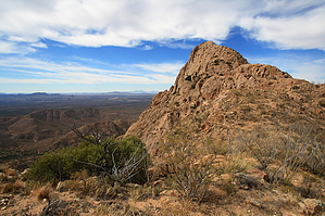
An Elephant (and your knees) never forgets by fricknaley  Overview OverviewThere are some famous peaks in the Santa Ritas, south of Tucson...Wrightson, Hopkins. None have the mystique of Elephant Head. The almost impossibly steep monolith crashing out of the western Santa Ritas into the desert seems to defy logic. Was this a place of sacrifice or violent deaths? Nobody knows for sure. But with old names including Picacho del Diablo and Cerro de Los Muertos, one must wonder. It turns out there is a way to the top requiring some trail hiking and class 3 scrambling with a very short class 4 move right before the summit. The exposure (mostly) feels worse than it is. The views from the top are worth every drop of blood and sweat.
The first part of this trail utilizes the Elephant Head Bike trail and the Quantrell Mine trail, described here on HAZ by Jeff MacE. Check that out to familiarize yourself with the lay of the land and trails you will use. The hike begins on the Elephant Head Bike trail, which takes off just across the street from the pullout, where you can park for this hike. The trail is a narrow single track cutting through the desert and initially heading northwest, then north up to a little saddle at the south end of the ridgeline leading out to the impressive Peak 5139. From this saddle (about 0.6 miles in), the trail drops down into Chino Basin with great views. At about 0.9 miles, you come to the signed intersection with the Quantrell Mine to your right and Elephant Head continuation to your left. Take a right onto the Quantrell Mine Trail and circle the eastern and northern end of the beautiful Chino Canyon as you head up to the first of the mines. The trail resumes a gradual climb the rest of the way to your takeoff for the scramble to Elephant Head. All the while, Elephant is coming more and more into your view. You reach the takeoff point for your scramble at about 1.9 miles from the car. A steep drainage into Chino Canyon falls off to your left, and a distinct (and likely cairned) route will break off and down to your left and head straight down into it. This is not a formal trail, but hikers with experience will have no trouble following the route down. It is steep, and the footing is pretty bad. You will drop about 500 feet in less than a quarter-mile to the canyon bottom, which offers a nice riparian surprise. During the right time, there will be water and possibly small falls in here. Pick up the route leading up the north wall of the side canyon and continue your quad-burning ascent up to the ridgeline running west to Elephant Head. Again the route is faint, but you should have no real issues following it up. The footing is worse on this end...like a zillion little marbles. Once you hit the ridgeline, take a breather and catch your jaw as it tries to fall off as you take in the majestic views east of the Santa Rita high country. The route to Elephant head now heads west along the ridgeline, skirting over and often north(right) of the smaller peaks and high points until the base of Elephant Head is achieved. From here on out, it is basically a class 3 scramble to the top. The route is generally worn enough and/or cairned to make your way. There is no formal correct way, but often enough, a several hundred-foot vertical drop will keep you heading in the correct direction. For the most part, the correct route hugs the northern edge of the formation, and when it doesn't, you are often in cracks and crevices of the ridge heading up. There IS exposure, but often not as bad as it seems. If you feel like you are tightrope walking and playing with death, you are likely off route. Near the base of the final short section to the summit is a short, maybe 10-foot, class 4 wall you must scramble up. If there's an easier way, I could not find it. This is the only real tricky part, but there's a little tree at the base of it willing to catch you should you fall and hopefully keep you from a several hundred-foot plunge. Once up here, it's maybe a hundred feet or so up a shallow crack in the middle of the steep ridgeline to the summit. On top, the most incredible views of Hopkins, Pete Mountain, Wrightson, and the Crest await you to the east. Little Elephant Head and Peak 5139 to the south. North all the way to the Catalinas. People have left all kinds of little elephant decorations and toys at the top over the years. Please be as careful, if not more so, on your way down. Though the exposure is often not as bad as it feels, there are definitely sections on this climb where a fall could lead to serious injury or death. This is not a hike to be taken lightly, but it is an enchanting experience. Check out the Official Route and Triplogs. Leave No Trace and +Add a Triplog after your hike & climb trip to support this local community. | |||||||||||||||||||||||||||||||||||||||||||||||||||||||||||||||||||||||||||||||||||||||||||||||||||||||||||||||||||