Route Editor

| Guide | ♦ | 9 Triplogs | 0 Topics |
details | drive | no permit | forecast | 🔥 route |
stats |
photos | triplogs | topics | location |
| 143 | 9 | 0 |
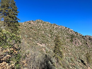
You gotta want it! by John10s   Overview OverviewSaddle Mountain can be accessed with a relatively short hike starting with two miles on its namesake Saddle Mountain Trail #91, followed by a steep, brushy off-trail ascent to the peak at 6,535'. Pants, gloves, and other protective gear are recommended to reach the summit, which is also covered in brush. Many familiar landmarks are visible from the top, though Saddle Mountain doesn't offer the full 360° views of many other Mazatzal summits thanks to the thick foliage. Between the obstructed views at the top and the bushwhack required to get there, this is one of the less commonly visited peaks in the area. Hike The hike begins from Mormon Grove Trailhead at the end of FR 25. If you're using Google Maps to drive to the trailhead, be aware that it may try to route you through private property at Cross F Ranch, so take note of the driving directions below. Saddle Mountain Trail #91 begins with some gentle uphill and then levels off quickly. A little over a half mile in, you'll reach the intersection with Little Saddle Mountain Trail #244, where you'll connect with AZT Segment #22 as you continue straight on Saddle Mountain Trail past some interesting geology, with a colorful mix of red and white formations.
Look for a suitable gap in the brush to start the climb. The brush is especially thick leaving Potato Patch, with a lot of catclaw mixed in among the other branches at the base of the hill as you head toward a distinctive rock outcropping. The brush becomes a little less dense and less thorny as you continue up the ridge, and Bartlett Reservoir comes into view to the southwest. Approaching the southern peak, you'll reach the top of the ridge at approximately 33.956486, -111.519042, where the views open up to the north. Working your way around the slope at the base of the southern peak, the brush gets thicker again, and the summit will come into view. From here, there are ~400 feet of elevation left to gain. Aim for the saddle between the two peaks, looking for the path of least resistance, which will be challenging with only a few brief breaks in the brush. You may need to do some light scrambling up or around some small rock outcroppings, and the terrain is loose and steep on the way up to the saddle, but there are plenty of branches to hold onto. Near the saddle, I encountered some signs of clipping and a semi-cleared path that made things a little simpler while it lasted. Once on the saddle, continue toward the peak, where you'll face a final, simple scramble up to the flat summit. Saddle Mountain provides some impressive views in every direction, just not at the same time--thanks to the ever-present brush, you'll have a hard time finding a spot that doesn't have obstructed views in at least one direction. Mt. Ord, Iron Dike are visible to the east, with the Sierra Anchas further beyond; looking north, you can see Sheep Mountain, Mt. Peeley, and Mazatzal Peak. And to the west/southwest, you can see Bartlett and Horseshoe Reservoirs and S B Mountain. Four Peaks, the Superstitions, and the top of Weaver's Needle are visible on the southeastern horizon. Look for the "SADDLE" benchmark, placed in 1963, which may be a little difficult to locate beneath the branches, but two reference markers provide some clues. As of 2023, there's a summit register not far from the benchmark and RMs. There aren't many open areas to sit down and enjoy the surroundings, but take in the views and prepare to battle the brush back toward Potato Patch, descending the same way you came up. You can return to Mormon Grove Trailhead or extend the hike with some easy miles continuing on the well-maintained Saddle Mountain Trail to Story Mine or beyond, with multiple trail connections in that general vicinity. Check out the Official Route and Triplogs. Leave No Trace and +Add a Triplog after your hike to support this local community. | ||||||||||||||||||||||||||||||||||||||||||||||||||||||||||||||||||||||||||||||||||||||||||||||||||||||||||||||||||||||||||||||||||||||||||||||||||||||||||||||||||||||||||||||||||||||||||||||||