Overview
South Mountain Park and Preserve is comprised of three distinct metamorphic mountain ranges. The southwestern Gila and northwestern Ma Ha Tauk are primarily Estrella Gneiss and Komatke Granite. Whereas the east side Guadalupe is a slightly more diverse Tertiary pluton with three phases. This lasso loop concentrates on exploring most of the aforementioned first range and includes a popular and easy bonus peak named Goat Hill.
Hike
If one follows the current updated signposts, a CCW direction would track Bursera (green), Lost Ranch (purple), Gila (blue), National (brown), and then Bursera (green) again. Hikebot may have to reluctantly update to this sequence once the City of Phoenix finalizes its trail maps. If one uses linked HAZ guides, the progression starts on the Pyramid Trail, continues up to the National Trail, meanders over to Goat Hill and then finishes on the Bursera Trail.
Synopsis
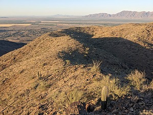
When considering mileage and AEG, this moderate loop hike is perhaps the second most challenging of the nineteen HAZ-listed South Mountain - Hikes. When approaching the hill, make sure to keep an eye out for Mike, the rarely spotted and enigmatic goat who's sometimes perched at this 2526-foot apex.
WARNING! Hiking and outdoor related sports can be dangerous. Be responsible and prepare for the trip. Study the area you are entering and plan accordingly. Dress for the current and unexpected weather changes. Take plenty of water. Never go alone. Make an itinerary with your plan(s), route(s), destination(s) and expected return time. Give your itinerary to trusted family and/or friends.
Permit $$
None
Directions
Road
Paved - Car Okay
To Bursera Trailhead From I-10 going S exit on 202/Pecos Road. Go W on Pecos Road for about 9 miles and turn right on 17th Avenue. Turn left onto Chandler Boulevard and go 0.3 miles to 19th Avenue, turn right(north) with a quick left into the trailhead.
From PHX (I-10 & AZ-51) - 22.6 mi, 28 mins From TUC (Jct 1-10 & Grant) - 104 mi, 1 hour 46 mins From FLG (Jct I-17 & I-40) - 166 mi, 2 hours 48 mins
 Route Editor

 Overview