 Route Editor

| Guide | ♦ | 4 Triplogs | 0 Topics |
details | drive | permit | forecast | 🔥 route |
stats |
photos | triplogs | topics | location |
| 23 | 4 | 0 |
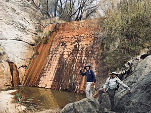
Paradise, with year round water by rvcarter   Background BackgroundBear Creek begins at Bear Saddle. An excellent viewpoint reached out of the General Hitchcock Campground off Catalina Highway. The saddle is roughly between the Green and Guthrie Mountains. Along its path to the southwest, it picks up the drainage known as Willow Canyon (home to the famous Seven Cataracts). It arrives eventually at the Sycamore Reservoir, located on East Fork Trail #39, about 1.7 miles west of the Gordon Hirabayashi Recreation Site (known locally as Prison Camp). Continuing southwest, it passes over the Sycamore Dam, then through a wild, densely vegetated canyon with no hint of a trail where it joins a trail most Tusconan hikers are very familiar with, Bear Canyon #29. Bear Canyon #29 is probably best known for the fabulous, heavily visited Seven Falls, reached most frequently by hikers out of the Sabino Canyon Recreation Area. Most visitors never go past Seven Falls, but some of the most beautiful parts of Bear Canyon, although nothing rivals the falls, are north of the falls.
Hike We hiked upstream from the Bear Canyon Trailhead and exited at Prison Camp, and this is the suggested direction for first-timers. My hiking buddies climbed Seven Falls and hiked in the streambed for about a mile for some extra fun scrambling before exiting the trail for lunch. There was virtually no flow over the falls on that day, only some pools with slowly stagnating water. After the trail turned back to the NNE, several pools with substantial water and some flowing water were present. One eventually reaches the last crossing of Bear Creek, where #29 continues up a switchbacking route toward its terminus with East Fork #39. This is where one departs upstream ENE for the bushwhack up to Sycamore Dam. You are immediately immersed in a densely vegetated wetland area with lots of boulders (some as big as your house), pools of water, and large cypress trees. Our hike was at the end of an arid period, but there was still a lot of flowing water. It was like an oasis, where one could boulder hop, swim, and marvel at the lush wetland that could exist in the desert after such a drought. I should note that headway would be a lot more difficult during wetter conditions and maybe inadvisable after significant rain. There are surprising few thorny bushes and plants, and almost no catclaw, in the canyon. But, the going is slow because one has to navigate around the pools and downed trees to make way up the canyon. There are a couple of places where the scrambling is class 3, and most people will want to climb around a few dicey spots where a mistake could result in a quick dip. However, there is little significant exposure along the entire route. As you near Sycamore Dam, watch for the sharp left turn up mostly slickrock for the final few hundred yards. One earlier track on HAZ showed a group exiting the canyon straight toward #39. If you continue up to the dam, you have the pleasure of a class 3 scramble to reach the top. Watch your footing here because the exposure and the consequences of a slip are considerable, all when your boot soles may be wet, and you may be tired. Take a rest here and enjoy the marvelous dam and the special canyon you have just seen, then head up East Fork #39 to the Prison Camp parking lot. Caution People who are not used to hiking off-trail will probably not enjoy this hike. However, if you like rock scrambling, boulder hopping, and wild canyon bushwhacking, try it, but with a partner. Note None of the areas mentioned in this description are included in the restricted area associated with the Big Horn Sheep Reintroduction Project. Check out the Official Route and Triplogs. Note This is a moderately difficult hike. Leave No Trace and +Add a Triplog after your hike to support this local community. One-Way Notice This hike is listed as One-Way. When hiking several trails on a single "hike", log it with a generic name that describes the hike. Then link the trails traveled, check out the example. | ||||||||||||||||||||||||||||||||||||||||||||||||||||||||||||||||||||||||||||||||||||||||||||||||||||||||||||


