 Route Editor

| Guide | ♦ | 108 Triplogs | 1 Topic |
details | drive | permit | forecast | 🔥 route |
stats |
photos | triplogs | topic | location |
| 618 | 108 | 1 |
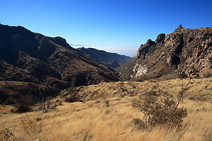
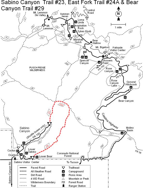
Second Fiddle to None by fricknaley  Background BackgroundBear Canyon shares its lowest elevations in the Sabino Canyon Recreation Area with its famous neighbor to the west (Sabino). Like Sabino, Bear Canyon thunders relentlessly up into the coniferous Catalina high country and is simply huge. Bear Canyon's claim to fame is, of course, the spectacular Seven Falls. But there's more, so much more to the huge, beautiful canyon than that. Bear Canyon is no Boy Wonder to anyone! Hike This description starts from the common parking area at Sabino Canyon and assumes one will be walking the entire way. There is a tram to the official trailhead that saves you about 1.8 miles... but come on, this is a hiking website :)
Immediately the canyon closes in with its towering walls of distinctive banded gneiss. The rocky creek bed is initially to your right and is lined with nice trees, including sycamore and cottonwoods. There is often water trickling along, sometimes it is roaring and sometimes it is dry. The trail will gradually climb over the next 2.2 miles to Seven Falls. There are numerous creek crossings. Generally, these have enough rocks to cross without getting wet. If the water is going strong, there will be several little falls everywhere. In the early winter, the tree color along the creek is superb. There are basically 6 crossings before the falls. The last one crosses west to east, and after attaining the east bank of the creek, begins to climb up the east wall of the canyon. This is a little steeper but levels out on a shelf looking down over the creek. After another roughly 0.4 miles you will see Seven Falls and come to a signed spur trail to the falls. The spur drops down to your left. If you have time, hit the falls up for a visit. From the spur, follow the signed continuation of Bear Canyon #29 up and to the right. The trail is going to switchback rather sharply higher up the east wall of the canyon offering multiple awesome views of the falls and allowing you to hear their beautiful song for that much longer. Eventually, the trail will cross over a side draining canyon and climb above the falls to continue further up Bear Canyon. Things change here. You enter the beginnings of a grassy, more shallow, and intimate canyon. After all that climbing you end up still on the east side of the canyon, but again much closer to it. If there is water there will be several pools and falls, and the colorful trees are back. This section of the trail is absolutely excellent. Any number of spots would be a great point to head down to the creek and chill out. At about 6.2 miles from the car, you make the last creek crossing (punctuated by a nice sycamore), heading back over to the west side and then climbing away rather sharply up above the canyon into the endless rolling grassy hills high above Bear Canyon. Looking back south will afford increasingly great views down canyon, including Thimble Peak and the mighty Santa Ritas south of Tucson. Shortly thereafter, Bear Canyon falls away to your right heading out towards Sycamore Reservoir. Meanwhile, you enter the low end of Sycamore Canyon, which is more shallow and narrow. This area was burned in the 2003 Aspen Fire but is coming back. There are scattered trees and burnt ghosts, and overall the area is reminiscent of Geronimo Meadows on the Esperero Trail. Along this passage, you will attain the highpoint of the trail, at about 4838 feet. From here it's a gradual descent the rest of the way. At roughly 8 miles from the car is a sizable cairn, and a discrete trail breaks off right. This is an established if unnamed, connector trail to the Sycamore Reservoir trail. Stay straight/left on Bear #29 and descend a gradual 0.5 miles to the end of the trail. The trail ends at an intersection of Sycamore Reservoir #39 and East Fork #24a trails at a superb saddle. The maps don't seem to name this saddle, though the Coronado National Forest webpage refers to it as Bear Saddle. From here you can head back the way you came or take the East Fork trail to Sabino Canyon trail #23 and come back home on the Phoneline trail. Another option would be a shuttle hike via Sycamore Reservoir up to Prison Camp.
Coronado FS Details Bear Canyon Trail leads upstream from the Lower Bear Picnic Area at the end of the Bear Canyon shuttle route. The trail crosses the stream several times in its first two miles and provides spectacular views of both Sabino and Bear canyons as it climbs to Bear Saddle. There it intersects the East Fork #24A and the Sycamore Reservoir #39 trails. The East Fork Trail follows Sabino Creek 2.1 miles to the junction with Sabino Canyon Trail. From this point it is 2.5 miles back to the end of the road where hikers can catch a shuttle bus ride (for a fee) or walk back to your car to complete a 13.4 mile loop. Since horses are not permitted on the shuttle road, equestrians must use the Phone Line Trail #27 (4.5 miles) to complete a loop. Check out the Official Route and Triplogs. Leave No Trace and +Add a Triplog after your hike to support this local community. One-Way Notice This hike is listed as One-Way. When hiking several trails on a single "hike", log it with a generic name that describes the hike. Then link the trails traveled, check out the example. | ||||||||||||||||||||||||||||||||||||||||||||||||||||||||||||||||||||||||||||||||||||||||||||||||||||||||||||||||||||||||||||||||||||||||||||||||||||||||||||||||||||||||||||||||||||||||||||||||||||||||||||||||||||


