username
X
password
register
for free!
help
  

Ocotillo Trail - Kartchner, AZ

Guide 6 Triplogs  0 Topics
  2.5 of 5  
Fav
Wish
0
details
drive
permit
forecast
route  
stats
photos
triplogs
topics
location
12 6 0
Statistics
tap row or icons for details
Difficulty 1 of 5
Route Finding 1 of 5
Distance Loop 1.78 miles
Trailhead Elevation 4,787 feet
Elevation Gain -230 feet
Accumulated Gain 129 feet
Avg Time One Way 1.5 hours
Kokopelli Seeds 2.21
feature photo
Photos Viewed All MineFollowing
11  2024-04-09 paulhubbard
1  2023-11-22 pseudalpine
Author
author avatar Guides 7
Routes 19
Photos 3,021
Trips 191 map ( 756 miles )
Age 67 Male Gender
Location Mesa, AZ
Associated Areas
list map done
Tucson Region
Historical Weather
Trailhead Forecast
Radar Map
Expand Map
Preferred Feb, Jan, Dec, Mar → 7 AM
Seasons   ALL
Sun  5:59am - 6:42pm
Official Route & 1 Rt
 
0 Alternative


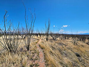
An Alternative to the Caverns
by paulhubbard

Overview
While the Caverns are of course the main attraction at Kartchner Caverns State Park, the new Ocotillo Trail is a nice wander, offering a taste of the Whetstone Mountains and panoramic views of the Sonoran Desert and Dragoon Mountains in the distance.


Hike
The trail starts right outside the Discovery Center and begins as the Foothills Loop trail. We took the loop counter-clockwise. The first 1/4 mile of the Foothills Loop trail skirts the Discovery Center and roadway up to the caverns, then heads off to the desert. We encountered a small herd of whitetail deer here. After 1/2 mile the Ocotillo Trail takes off to the right, and heads up into what I call an "Ocotillo Forest." It's obvious where the trail gets its name.
remove free decal offer
While climbing gently into the Whetstone Mountains' foothills, you're circling the hill that houses the Caverns. You'll go through a couple of fenceline gates as you near the top of the trail, and the views are worth stopping for. You eventually meet back up with the south side of the Foothills Loop trail which leads you the last mile back to the Discovery Center.

Gate Policy: If a gate is closed upon arrival, leave it closed after you go through. If it is open, leave it open. Leaving a closed gate open may put cattle in danger. Closing an open gate may cut them off from water. Please be respectful, leave gates as found. The exception is signage on the gate directing you otherwise.

2024-04-10 paulhubbard
  • Kartchner Brochure
    area related
    Kartchner Brochure
  • Kartchner Map
    area related
    Kartchner Map


Check out the Official Route and Triplogs.
Leave No Trace and +Add a Triplog after your hike to support this local community.

One-Way Notice
This hike is listed as One-Way.

When hiking several trails on a single "hike", log it with a generic name that describes the hike. Then link the trails traveled, check out the example.
WARNING! Hiking and outdoor related sports can be dangerous. Be responsible and prepare for the trip. Study the area you are entering and plan accordingly. Dress for the current and unexpected weather changes. Take plenty of water. Never go alone. Make an itinerary with your plan(s), route(s), destination(s) and expected return time. Give your itinerary to trusted family and/or friends.

 Permit $$
AZ State Parks more info
2023 Day Use Fees range from $2–$30

Coronado Forest
MVUMs are rarely necessary to review unless mentioned in the description or directions
Coronado Motor Vehicle Use Maps (MVUMs)


 Directions
or
 Road
Paved - Car Okay

To hike
From Tucson, take I-10 east for 45 miles to Hwy 90 south, just before Benson. Go 9 miles south to Kartchner Caverns State Park. Park and go to the Discovery Center where the trail begins.
page created by joebartels on Apr 10 2024 9:45 am
 90+° 8am - 6pm kills
helpcorrectionissue

end of page marker