username
X
password
register
for free!
help


Scorpion Alley - Hawes, AZ

Guide 35 Triplogs  0 Topics
  3.3 of 5  
Fav
Wish
1
details
drive
no permit
forecast
route  
stats
photos
triplogs
topics
location
80 35 0
Statistics
tap row or icons for details
Difficulty 1 of 5
Route Finding 1 of 5
Distance One Way 0.84 miles
Trailhead Elevation 1,602 feet
Elevation Gain -52 feet
Accumulated Gain 17 feet
Avg Time One Way 20 minutes
Kokopelli Seeds 0.9
 Backpack No
 Dogs not allowed
feature photo
Photos Viewed All MineFollowing
Will recalculate on button tap!
3  2025-01-10
Bush Lite Scorpion Alley Loop
CannondaleKid
6  2024-09-01 DarthStiller
8  2022-06-28
Mountain Biking (Big Sister)
CannondaleKid
16  2021-08-21 DarthStiller
5  2020-11-28
Hawes North
Nightstalker
5  2020-09-28
Salt #100 Scorpion WH Stinger Alley Loop
CannondaleKid
1  2019-05-11
Scorpion Bush Loop
CannondaleKid
2  2019-05-05
Bush Scorpion Loop
CannondaleKid
Page 1,  2
Author
author avatar Guides 44
Routes 162
Photos 24,766
Trips 2,411 map ( 18,558 miles )
Age 75 Male Gender
Location Mesa, AZ
Associated Areas
list map done
Phoenix Region
Historical Weather
Trailhead Forecast
Radar Map
Expand Map
Preferred Jan, Dec, Feb, Mar → 8 AM
Seasons   Late Autumn to Late Spring
Sun  6:02am - 6:48pm
Official Route & 2 Rts
 
3 Alternative


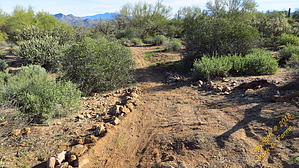
Bowling for scorpions
by CannondaleKid

 
Overview
This is another mountain bike trail added to the Hawes Trail System in December 2018. This 'connector' trail will link the new Scorpion Trail to the Stinger Trail.


Warning
This trail is designed for and primarily to be used by mountain bikers, but you may encounter hikers, equestrians, and wild horses, so be aware.
remove free decal offer
History
This trail, the Scorpion Trail, and the Stinger were authorized by the Forest Service and an environmental assessment was completed in 2008... it just took ten years before it received the necessary funding. Part of the funding was from the Forest Service and part from outside groups.


Mountain Bike
Easy single-track trail with a nice flowing rhythm on a hard-packed gravel surface (some grass at the moment) featuring short straights, easy turns with few curved berms along a very minor but steady loss of elevation.

Hike
Very easy... no sandy washes, no thorny stuff, just a nice hard-packed surface. Due to the area being so flat, pretty much the only scenery will be the Palo Verde & Ironwood trees along with vegetation including jojoba, cholla, ocotillo, etc.

Water Sources
None - Bring your own. Please do not leave empty bottles along the trail or where you park.

2018-12-22 CannondaleKid


    Check out the Official Route and Triplogs.
    Leave No Trace and +Add a Triplog after your hike to support this local community.

    One-Way Notice
    This hike is listed as One-Way.

    When hiking several trails on a single "hike", log it with a generic name that describes the hike. Then link the trails traveled, check out the example.
    WARNING! Hiking and outdoor related sports can be dangerous. Be responsible and prepare for the trip. Study the area you are entering and plan accordingly. Dress for the current and unexpected weather changes. Take plenty of water. Never go alone. Make an itinerary with your plan(s), route(s), destination(s) and expected return time. Give your itinerary to trusted family and/or friends.

     Permit $$
    None


     Directions
    or
     Road
    Paved - Car Okay

    To hike
    NOTE: The closest trailhead to the east end of this trail is the Scorpion Trail TH on Bush Highway near MP 26.

    From the west: Exit Loop 202 / Red Mountain Freeway at Power Road.
    From the east: Exit Loop 202 / Red Mountain Freeway at McDowell Road and turn right on Power Road.
    Travel north to Milepost 26 (6 miles north of the 202/Power intersection) and park as far of the pavement yet still on the gravel shoulder.
    For the safety of horses, bikers, hikers, and drivers, please park at least 100 feet north or south of the horse crossing gate to provide a clear line-of-sight.
    page created by CannondaleKid on Dec 22 2018 2:48 pm
     90+° 8am - 6pm kills
    helpcorrectionissue

    end of page marker