Overview
Sunrise Peak is a popular hiking destination in the southeastern McDowell Mountains. This guide describes the hike to Sunrise Peak from the Adero Canyon Trailhead in Fountain Hills.
Hike
This hike utilizes several trails in both the Fountain Hills McDowell Mountain Preserve(FHP) and the Scottsdale McDowell Sonoran Preserve(MSP). From the trailhead in the FHP, the hike begins on the Promenade Trail, and then continues in the FHP on the Western Loop Trail and the FHP section of the Andrews-Kinsey Trail.
At that point, hikers enter the MSP and continue on the MSP section of the Andrews-Kinsey Trail to the Sunrise Trail; about 15 feet from this trail junction is the landmark hitching post. From the hitching post, it can be a bit daunting looking at the steep ascent up to the Sunrise Peak summit. However, there are lots of switchbacks, and the hike up is not as difficult as it looks. From the hitching post, first take the Sunrise Trail for a short distance, then take the Sunrise Peak Spur Trail up to the summit. From the summit, you can enjoy the views to the east of Fountain Hills below you and of Four Peaks, the Mazatzals, and the Superstitions further away; to the south and west, there are nice views of Scottsdale, Phoenix, and beyond. After enjoying the views on the summit, retrace your steps to return to the trailhead.
The hike to Sunrise Peak from Adero Canyon is a bit longer than going from the 4 starting points off of E. Via Linda in Scottsdale: the Lost Dog Wash Trailhead, 128th St., 136th St., or the Sunrise Trailhead (145th St.). However, the hike to Sunrise Peak is easier than the other four hikes because the bulk of the hike from Adero Canyon is on the Andrews-Kinsey Trail, which mostly has a smooth dirt surface with no long, steep ascents or descents. In contrast, the other four hikes are largely on the Sunrise Trail, which is rocky and has some steep ascents and descents.
WARNING! Hiking and outdoor related sports can be dangerous. Be responsible and prepare for the trip. Study the area you are entering and plan accordingly. Dress for the current and unexpected weather changes. Take plenty of water. Never go alone. Make an itinerary with your plan(s), route(s), destination(s) and expected return time. Give your itinerary to trusted family and/or friends.
Permit $$
None
Directions
Road
Paved - Car Okay
To Adero Canyon Trailhead From Loop 101 and Shea Blvd head east on Shea Blvd for 7.8 miles. Then turn left on N Palisades Blvd and continue 1.1 miles. Turn left at the stop sign onto Eagle Ridge Drive and continue 2.4 miles until you reach the Adero Canyon Trailhead. Note that along the way Eagle Ridge Drive first becomes N 143rd Way and then becomes N Eagle Ridge Drive.
• February 2019: There is road construction on Eagle Ridge Dr, and the last mile to the trailhead is on a well-graded, unpaved road. However, that section of the road will ultimately be paved.
• January 2020 FHP writes: Fountain Hills (Parks & Wildlife Dept..480-816-5100): Adero Cyn TH/Parking is presently "only" accessible for parking access at the closed chain link fence ~1 mile "prior-to" TH Parking on N. Eagle Ridge Drive. M-F Trailhead access from ~1 mile up road is only legal from 3pm daily. Sat & Sun TH access from ~1 mile up road is legal from dawn to dusk.
• 2020-02-15 Yoder writes: Road to trailhead parking is closed due to construction. You may want to go to the Sunrise Trailhead parking. • 2020-11-09 Grasshopper writes: Officially opened, and the road to the Parking / TH is now paved.
From PHX (I-10 & AZ-51) 43 min (32.3 miles) From TUC (Jct 1-10 & Grant) 2 h 7 min (131 miles) From FLG (Jct I-17 & I-40) 2 h 28 min (155 miles)
 Route Editor

 Overview
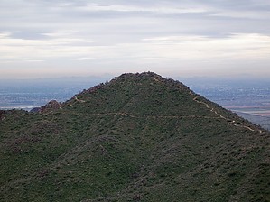


