Overview
The Javelina Willow Springs Crossover trail connects Willow Springs Canyon Upper with the Javelina Mine Trail and Willow Springs Tank Trail (Golden Eye Mine Trail). This trail's western portion is also called the Gold Eagles Nugget Trail. This is a short 1-mile trail that passes between two hills with a ridge in the middle, so it involves a little up and down. Being this is a crossover trail, it is a common trail for longer loop trails.
Hike
This trail from its eastern end starts 0.2 miles in on the Willow Springs Canyon Upper, where it drops into Willow Springs Creek near the Willow Springs Canyon Trailhead. From the creek, it heads west going uphill gradually for 0.6 miles with an elevation gain of about 150 feet. The Willow Springs Basin Trail splits off north at this point. There are some interesting rock formations just prior to this point. From this trail junction, the trail climbs about 125 feet in about 0.1 miles to the summit of this trail and then drops back down 100 feet to the junction with the Javelina Mine and Willow Springs Tank Trails. This trail is in good condition and easy to follow. This is a good trail to take around sunset. On the eastern portion of the trail there are good views of Weavers Needle which again is particularly good at sunset.
When hiking several trails on a single "hike", log it with a generic name that describes the hike. Then link the trails traveled, check out the example.
WARNING! Hiking and outdoor related sports can be dangerous. Be responsible and prepare for the trip. Study the area you are entering and plan accordingly. Dress for the current and unexpected weather changes. Take plenty of water. Never go alone. Make an itinerary with your plan(s), route(s), destination(s) and expected return time. Give your itinerary to trusted family and/or friends.
Permit $$
None
Directions
Road
Connector trail - Not Applicable
To Willow (arbitrary/unofficial) Trailhead Apache trail Northeast from Idaho Road in Apache Junction. About 10 miles northeast to highway marker 204. Just before the marker turn left into parking area. A reference point is the Needle Vista viewpoint on the south of the highway. The trailhead is not marked but is a clear pulloff area just before the 204 sign.
From PHX (I-10 & AZ-51) 42.5 mi - about 48 mins From TUC (Jct 1-10 & Grant) 136 mi - 2 hours 14 mins From FLG (Jct I-17 & I-40) 186 mi - 3 hours 2 mins (Trailhead is generic)
page created by markthurman53 on Mar 28 2019 10:20 pm
 Route Editor

 Overview
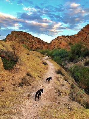


