 Route Editor

| Guide | ♦ | 7 Triplogs | 0 Topics |
details | drive | permit | forecast | 🔥 route |
stats |
photos | triplogs | topics | location |
| 78 | 7 | 0 |
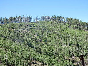
Shoo Flys Don't Bother Me by DixieFlyer   Overview OverviewWard Peak (elevation of 9,570' with 320' of prominence) is one of several 9,000' or higher peaks that you can access from Crest Trail #270 along the Chiricahua Mountains Ridgeline. Note For this guide, the hike begins on the Crest Trail at Round Park (31.86871,-109.28502). This is near the point on the Crest Trail where it intersects Fly Peak Trail #337 on the south from Flys Peak, and where Bear Wallow Trail #333 heads northeast.
From Round Park, you will head south-southeast up to Ward Peak (31.86517, -109.28759). The hike is off-trail up to the summit, and you'll need to pick a route through vegetation (mostly small aspen trees that are quite thick in places) and deadfall. It is not the easiest off-trail hike, but it is certainly not the worst. With a little perseverance, most hikers can successfully ascend the summit. There are quite a few trees at the summit, which limit the views. Nonetheless, there are good views of Chiricahua Peak. On the descent, you can either go back the way that you came up, or if you want to hike toward Chiricahua Peak, you can head south and hit the Crest Trail going toward Chiricahua Peak. Less vegetation and deadfall to deal with make the descent on the south side easier. Synopsis If you are looking to bag some peaks in the Chiricahua Wilderness, this peak is a good one to tackle, particularly if you are already hiking up to either Flys Peak or Chiricahua Peak. Check out the Official Route and Triplogs. Leave No Trace and +Add a Triplog after your hike to support this local community. One-Way Notice This hike is listed as One-Way. When hiking several trails on a single "hike", log it with a generic name that describes the hike. Then link the trails traveled, check out the example. | ||||||||||||||||||||||||||||||||||||||||||||||||||||||||||||||||||||||||||||||||||||||||||||||||||||||||||||||||||||||||||||||||||||||||||||||||||||||||||||||||||||||||||||||||||||||


