 Route Editor

| Guide | ♦ | 27 Triplogs | 0 Topics |
details | drive | permit | forecast | 🔥 route |
stats |
photos | triplogs | topics | location |
| 325 | 27 | 0 |
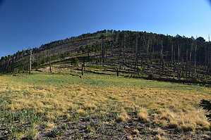
Scenic Crest Hike by markthurman53   CREST TRAIL OVERVIEW CREST TRAIL OVERVIEWThe Crest Trails North end is along the Barfoot Park Road and continues southward to Chiricahua Peak, Sentinel Peak, and Monte Vista Peak. This trail is 14.2 miles long and divided into three sections, each traversing a ridge or crest. From Chiricahua Peak, there are three main ridges; to the north, a ridge running to Buena Vista Peak, to the southwest, a ridge running to Monte Vista Peak, and to the southeast, a ridge running to Sentinel Peak. Each of the ridges divides the trail into three sections and two side trails. THREE MAIN ⅄ LEG SECTIONS
6.2 miles: on the north side of Chiricahua Peak Crest Trail #270B - Jct Sdl to Monte Vista Pk 3 miles: Along the west side of Chiricahua Peak Crest Trail #270C - Jct Sdl to Sentinel Peak 5 miles: Along the east side of Chiricahua Peak TWO SHORT OPTIONS Crest Trail #270A - Jct Sdl to Aspen Sdl 0.9 miles: Jct Saddle > Chiricahua Pk > Aspen Sdl on the SE side of Chiricahua Pk Crest Trail #270D - Chiricahua Bypass 1.2 miles: Aspen Sdl to Chiricahua Sdl along the south side of Chiricahua Pk Access to the Crest Trail at various points can be done from Rustler Park to the north, Turkey Creek to the west, Cave Creek to the east, and Rucker Canyon to the South. Only the Rustler Park access is direct; the rest require 5 to 10-mile connecter trails with 3 to 4000 feet of elevation change. These Trails are all at around 9000 feet through heavily wooded areas, and some areas burned pretty severely over the last 20 years. The forest is in different stages of recovery. Weather can change suddenly at this elevation, and if on the trail, be prepared for whatever it can throw at you; there is no quick exit from this trail. CREST TRAIL #270 Description The trailhead for the Crest Trail #270 is along the Barfoot Park Road FR357, about 500 feet after turning off FR42D Rustler Park road. A sign marks the trail along with Barfoot Lookout. The Horseshoe 2 Fire swept through this area in 2011, so there is a lot of deadfall. The trail has been mostly cleared, so no need to climb over fallen trees. The trail starts at about 8400 feet and will gradually climb up to 9400 feet over the next 6 miles. A half-mile up from the trailhead is the first trail junction, the Barfoot lookout on Buena Vista Peak, and the trail to Barfoot Park. Barfoot Lookout offers good views over Rustler Park and Barfoot Park and distant views all around, as the name of the peak implies. There is no lookout tower on Buena Vista Peak. The Crest trail Continues south just below the crest and stays fairly level until just before Rustler Park, where it drops down about 150 feet. The trail along Rustler Park is barren of trees with a few exceptions. In the spring and summer, the grasses and ferns are quite thick. A spur trail heads down to rustler Park and is less than 0.1 miles, so this is also a good starting point for the Crest Trail. After leaving Rustler Park and 1.7 miles in is the junction with the Bootlegger Trail #257. This trail heads down to the west into Turkey Creek. Another 1 mile and the junction with the Rock Canyon Trail comes up from Turkey Canyon. The trail has climbed 500 feet since Rustler Park. The fire damage is minimal along this stretch; most of the hiking is through pine and fir forest. At 3.7 miles in and an elevation gain of about 600 feet is the Wilderness boundary near Flys Park. Three other trails connect at Flys Park, The Centella Trail #334, Flys Peak Trail #337, and the Long Park Trail #42D. This area was hit by fire in 2011 but is recovering quite nicely with Aspen and young fir trees. There is a nice view of the north side of Flys Peak from this junction. Aspen trees cover the north slope in response to the 2011 fire. This is a good destination if you want to go up to Flys Peak, a 0.8-mile 600-foot climb. The other option is the Centella Point Trail that offers great views over Cave Creek Basin. Still another option at this point is to take the Long Park Trail #42D back to Rustler Park. From Flys Park, the trail follows along the west side of Flys Peak, and at 4.3 miles, Saulsbury Trail #263 comes in from the west. This is another trail that heads down into Turkey Canyon. This junction is signed. Round Park is another 0.4 miles from the Saulsbury junction and the intersection with Bear Wallow Trail #333. This is a quaint little meadow that is kind of round. Good views to the north of the park of Flys Peak, the side that wasn’t hit by fire. Booger Spring Trail #347 is a short 0.2 miles and can be reached by going about 100 feet in on the Bear Wallow Trail. Not sure what the condition of this trail is or if it is even marked; I have never been there. It didn’t sound too appetizing. This junction is another good spot to turn around and do the Bear Wallow and Centella Point Trail before returning to Rustler Park. At this point, the Crest Trail has gained about 800 feet in elevation over 4.7 miles. From Round Park, it is another 0.6 miles to Cima Park, This section of the crest trail is on the east side of a low peak and was only lightly hit by fire so most of the trail is through old-growth forest. At Cima Park is the junction with the Greenhouse Trail #248. The Greenhouse trail heads down Cima Canyon to the East into the Cave Creek Canyon. The Crest trail now follows along the west slope of the crest and has a lot of fire damage. The views to the west are spectacular, and the first good views of Chiricahua peak are from along this section of trail. The Anita Park Trail #359 is about 0.9 miles from Cima Park. There used to be a sign marking this trail, but the last time I was up there, it was gone; the trail and the old signpost are easy to see if you are looking for it. Anita Park and spring are up the hill about 0.2 miles. 0.1miles after the Anita Park Trail is the End of the Crest Trail #270 at Junction saddle. Chiricahua Peak is in front of you about 300 feet up. It is called Junction Saddle because 4 trails intersect here. The Chiricahua Peak Trail or Crest Trail #270A, Crest Trail #270B to Monte Vista Peak, and the Crest Trail #270C to Sentinel Peak. The Crest Trail #270 has gained 1000 feet in elevation and 6.2 miles from the start at Barfoot Canyon Road. This trail is in good condition and gets moderate use. It is not uncommon to hike along this trail and not see anyone else. Despite the Horseshoe 2 Fire, this is quite a scenic trail, a good chance to witness the regeneration of a forest. The views from the trail are fantastic if the weather conditions permit. It is not uncommon to see Mule and White Tailed Deer along with Bears. Be warned that the trail signs mentioned in this post over time may not be there. Over a two-year period, I have witnessed the degradation of the signs, some now gone that were there a year ago. Check out the Official Route and Triplogs. Leave No Trace and +Add a Triplog after your hike to support this local community. One-Way Notice This hike is listed as One-Way. When hiking several trails on a single "hike", log it with a generic name that describes the hike. Then link the trails traveled, check out the example. | ||||||||||||||||||||||||||||||||||||||||||||||||||||||||||||||||||||||||||||||||||||||||||||||||||||||||||||||||||||||||||||||||||||||||||||||||||||||||||||||||||||||||||||||||||||||||||||||||||||||||||||


