username
X
password
register
for free!
help


Little Elephant Head - Santa Rita Mtns, AZ

Guide 8 Triplogs  0 Topics
  4.2 of 5  
Fav
Wish
0
details
drive
permit
forecast
route  
stats
photos
triplogs
topics
location
89 8 0
Statistics
tap row or icons for details
Difficulty 3 of 5
Route Finding 2 of 5
Distance Round Trip 3.32 miles
Trailhead Elevation 4,571 feet
Elevation Gain 560 feet
Accumulated Gain 1,000 feet
Avg Time Round Trip 2 hours
Kokopelli Seeds 8.32
 Interest Historic & Peak
 Backpack No
 Dogs not allowed
feature photo
Photos Viewed All MineFollowing
Inaugural Calculation on Button Tap!
7  2024-03-14 fricknaley
8  2022-12-17
Elephant Head - South Approach
trekkin_gecko
12  2022-12-17
Elephant Head - South Approach
johnlp
15  2022-12-17
Elephant Head - South Approach
chumley
28  2022-10-10 Mike_W
19  2021-01-16
Two Heads are better than One
DixieFlyer
12  2017-05-14
Elephant Head - South Approach
trekkin_gecko
Author
author avatar Guides 99
Routes 1,484
Photos 16,072
Trips 1,374 map ( 13,602 miles )
Age Male Gender
Location Fountain Hills, AZ
Associated Areas
list map done
Tucson Region
Historical Weather
Trailhead Forecast
Radar Map
Expand Map
Preferred Dec, Jan, Feb, Mar → Early
Seasons   Late Autumn to Spring
Sun  6:01am - 6:44pm
Official Route
 
3 Alternative


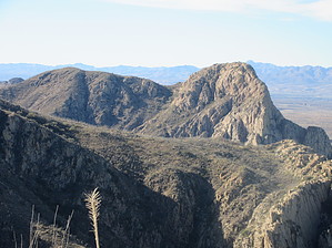
A pachyderm head a day keeps the doctor away
by DixieFlyer

 
Overview
Little Elephant Head (elevation of 5,139' with a prominence of 439') is in the western Santa Rita Mountains, lying just outside of the Mount Wrightson Wilderness. It is 1.4 miles south of its higher and better known sibling, Elephant Head.


Hike
The hike begins at the Elephant Head TH in Agua Caliente Canyon. This is the trailhead for the Elephant Head - South Approach hike.
remove free decal offer
From the TH, take Quantrell Mine Trail #141 for about 0.7 miles until you see a trail going off to your left (at GPS coordinates 31.70110, -110.93523). This trail is unnamed and unsigned, but there is generally a rock cairn at the junction. Take this well-worn and easy-to-follow trail to the summit of Little Elephant Head. There are 3-4 false summits on the way, but if you persevere, you will make it to the summit, where you can enjoy awesome 360-degree views of the surrounding area.

This is mostly a class 1 hike, although there is a bit of class 2 hiking along the way. The tread is mostly friendly, although there is a bit of scree and loose dirt. There is no climbing involved, but you will likely need to use your hands for balance in a couple of places as you near the summit.

History
This part of the Santa Ritas was home to some extensive mining in the early part of the 20th century. The mines produced considerable amounts of gold, silver, and lead ore during their heyday.

Synopsis
This is a tough 3-mile hike, and it will give you a good workout. Hardy hikers may wish to combine a hike to Little Elephant Head with a hike to Elephant Head; after all, two head are better than one!

2021-01-17 DixieFlyer


    Check out the Official Route and Triplogs.
    Leave No Trace and +Add a Triplog after your hike to support this local community.
    WARNING! Hiking and outdoor related sports can be dangerous. Be responsible and prepare for the trip. Study the area you are entering and plan accordingly. Dress for the current and unexpected weather changes. Take plenty of water. Never go alone. Make an itinerary with your plan(s), route(s), destination(s) and expected return time. Give your itinerary to trusted family and/or friends.

     Permit $$
    None

    Coronado Forest
    MVUMs are rarely necessary to review unless mentioned in the description or directions
    Coronado Motor Vehicle Use Maps (MVUMs)


     Directions
    or
     Road
    FR / Jeep Road - Car possible when dry

    To Elephant Head (arbitrary/unofficial) Trailhead
    From anywhere in Tucson, head south to I-19. Take I-19 south to exit 56 (Canoa). Take the east Frontage road south for three miles to Elephant Head road. Follow Elephant Head for about one and a half miles and turn right onto Mount Hopkins road. Take Mt. Hopkins road for 5.5 miles and turn north onto FSR 183, which is marked by the standard vertical FS road marker. Follow FSR for about two and a half miles until it approaches the basin of Agua Caliente stream. A large sign to the right of the road states "Dead End 2 Miles." Park here under the plentiful trees. Walk back down FSR 183 in the direction you just came for about 100 meters until you encounter the junction with FSR 930 - The Elephant Head Trail.

    2015-12-20 philmacduff writes: High clearance vehicles recommended on FSR 183. The road becomes impassable to cars with less than 9" clearance (even when dry) approximately 200m from the trailhead. Up until this point, with careful driving, it is doable with a decent 2WD car. You should be able to find a spot to park on the side of the road somewhere prior to this point. Be prepared to back down the dirt road if needed. Also, note that FSR 183 is not marked well from Mt Hopkins Rd as FSR 183. There is a small sign about 40 yards down the dirt road, but nothing else was visible from Mt Hopkins Rd.

    2014-03-03 andrewbares writes: Another rougher 4x4 entrance exists, on FR 4073. Same as above, exit 56 from I-19 and turn left on Elephant Head Rd. However, continue on Elephant Head Road and simply keep straight (turns into Hawk Way). Eventually, it'll turn into a dirt road that heads southeast. Continue on that dirt road. You'll reach a gate on your left, but continue straight (goes directly south now). Finally, you'll reach another gate at the end of a big open parking area, and you'll go left through that gate. Very soon after, you'll come to a 4-way intersection... turn right onto FR 4073, which has a marker a little way down the turnoff. This is where the road starts getting rougher. You'll cross through the wash and continue heading south for the rest of the drive. Stock 3rd generation 4Runners (1996-2002) will be perfectly fine. No rear lockers are needed. I recommend 9.5" of ground clearance. Low gears aren't even needed. It's just a rocky trail. At the very end, it will get quite narrow (and eventually turns into an ATV trail) so park where you feel comfortable.

    From PHX (I-10 & AZ-51) - 2 hr 37 min (155 miles)
    From TUC (Jct 1-10 & Grant) - 58 min (45.4 miles)
    From FLG (Jct I-17 & I-40) - 4 hr 40 min (298 miles)
    (Trailhead is generic)
    page created by DixieFlyer on Jan 17 2021 7:28 am
     90+° 8am - 6pm kills
    helpcorrectionissue

    end of page marker