Route Editor

| Guide | ♦ | 1 Triplog | 0 Topics |
details | drive | permit | forecast | 🔥 route |
stats |
photos | triplog | topics | location |
| 49 | 1 | 0 |
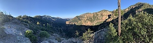
Tour of Destruction by Jackluminous  Overview OverviewThis is an extended loop trail around Rucker Canyon, which is a beautiful canyon in the southern Chiricahuas. It starts at the now-defunct Rucker Forest Camp, follows the Raspberry Ridge Trail #228 to intercept the Crest Trail #270, then follows the Crest all the way to Sentinel Peak. This route then follows the Baker Canyon trail #225 down to Price Canyon Trail #224, takes Price Canyon up to the eastern terminus of Rucker Canyon Trail #222, then returns to Rucker Forest Camp along the Rucker Canyon Trail. Warning With the exception of the Crest Trail and most of the Rucker Canyon Trail, which are in decent to excellent condition, most of the trails are in poor to exceptionally poor condition. Trail maintenance in the Chiricahuas is sporadic at best. Some of these trails are likely abandoned by the Forest Service. Be prepared for stretches of epic deadfall, massive washouts, rampant overgrowth, and segments of trail that are simply gone. I do not recommend anyone undertake this hike without a GPS, preferably one with communication capabilities.
I led a group of four intrepid companions on a three-day backpacking trip following this route. We started early on a Friday morning at Rucker Forest Camp, which is at the time of this writing under a Forest Service closure order due to massive flooding in Rucker Canyon. According to the closure order, the Rucker Forest Camp campground is slated for removal. Parking at the trailhead is permitted and the Rucker Canyon Trail is open. From Rucker Forest Camp the Rucker Trail heads east to intercept Bear Canyon and the Raspberry Ridge Trail, which heads north. This area was completely washed away, though the Raspberry Ridge Trail was still visible and followable on the west side of the creek. There was no sign at the junction. The Raspberry Ridge Trail soon disappeared in the creek. The route follows a side drainage to the northeast, with lots of boulder scrambling. The trail reappeared and took off to the east to ascend to Raspberry Saddle. We relied on a GPS to locate the trail, and it would have been difficult to see without the aid. The trail was faint and overgrown but largely followable up to the saddle, with lots of switchbacks. The stretch from the canyon bottom to the saddle was very steep. There were areas of deadfall and washed-out trail, occasional overgrowth obscuring the trail, and stretches of trail that were simply gone. However, it was fairly easy to pick the trail back up again when it got lost. GPS was very helpful. From the saddle, the trail was at first very faint and overgrown but followed the ridge predictably. The trail did become more clear a ways up, though some stretches were obscured by wildflowers and grasses. The intersection with the Crest Trail was signed. The Crest Trail was generally in good condition but was obscured by grasses and wildflowers at times. Depending on where one is on the trail, there are excellent views into Rucker Canyon below, panoramic vistas of southeastern Arizona and western New Mexico, and even far into Mexico. Our group camped at Aspen Saddle. There were good water sources nearby, notably Ojo Agua Fria and Eagle Spring. At the time we were there, Ojo Agua Fria was not in the best condition and Eagle Spring was the better of the two, though we were able to get good water at both. From Aspen Saddle we continued on the Crest to Sentinel Peak. The Crest Trail's quality declined somewhat the closer we got to Sentinel Peak, presumably because the area sees relatively little traffic. On the larger saddles between peaks the trail would frequently be overgrown and the tread faint, but still followable. GPS was handy but probably not necessary. Sentinel Peak was overgrown with aspens, though the trail was in relatively good shape. There was some deadfall on the trail, but dead aspens are very light and it was easy to toss most of them off the trail. Just before the last switchback to the peak is a junction with the Baker Canyon Trail. This junction was obscured by aspen overgrowth and hard to see. At the top of Sentinel Peak, the aspens blocked most of the views except a small window to the east. The remnants of an old fire lookout were still there, having been dismantled by the forest service in the 1970s. Some interesting debris was scattered about the peak. The Baker Canyon Trail takes off from the aforementioned obscured junction. At the upper end of the trail, it was heavily overgrown with oak but was largely followable. Some areas of tread could have used some love. After a bit, the trail entered a pristine forested area and the tread was excellent, with only occasional deadfall. At one point an animal trail passed beyond a faint switchback, but that's about as bad as it got until we reached Baker Saddle. Then things got worse. A lot worse. Baker Saddle had burned badly in the past and resembled a moonscape, with no evidence of trails even though the saddle is a junction for several. With a GPS we could find where the original sign was, and while it was somehow still standing it was burnt so badly it was no longer legible. We did pick up the trail again as it left the saddle, but only briefly before it entered a steeply sloped, burned area with lots of scree. The trail at this point was largely wiped out for the extent of the burned area, which was considerable. When it entered a more lightly burned area with standing live trees it showed up again, very faint, but followable. It switchbacked steeply down into Baker Canyon, with occasional deadfall and overgrowth. When it reached the canyon bottom it disappeared completely, and it was boulder-hopping and scrambling over fallen trees for the entire length down to its intersection with Price Canyon. Progress was very, very slow. The intersection of Baker and Price Canyons was well signed and the trails were intact there. There was even room for tents. We pressed on up Price Canyon toward the junction with Rucker Canyon Trail. At first, the Price Canyon Trail was in good condition if a little overgrown here and there. It was easy to follow for a few tenths of a mile, and we found a place where water was flowing nicely and there were several nice pools where we could replenish our water supplies. After this, however, trail conditions deteriorated immediately. Dozens, possibly over a hundred dead trees choked the canyon. This, together with rampant overgrowth and boulders, made progress painfully slow. We did eventually reach the Shrine Cave, a cave about 10-15 feet deep in the west wall of the canyon. Migrants had frequented this route and set up the shrine in years past. It appeared not to have been visited in a long time. There are flat areas around this cave where one could pitch a tent, and the trail immediately before and after the cave was in good shape. When we arrived we contemplated camping here as it was dusk, but we needed to communicate with friends in Rucker Canyon who were expecting us that evening so we needed to reach the ridge above to get cell service. The Price Canyon Trail petered out quickly past the cave and once again was a scene of destruction, deadfall, and wild vegetation. We had to traverse the distance between the shrine cave and the Rucker Canyon Trail junction with headlamps. The trail junction was completely overgrown and obscured by sticker bushes and oak, and choked with deadfall. The word "impassable" really wants to lodge in my mind, except the fact that we did manage to pass, at night with no moon, and only headlamps to see by and a GPS to show us where the trail was. As we climbed out of Price Canyon the overgrowth lessened, and the sticker bushes gave way to oaks, which were much easier to contend with. We managed to make the ridge and found a flat area for tents there, and made camp. We communicated with our friends to let them know we were okay; they had a satellite communicator and would have signaled an SOS if we hadn't checked in. On Sunday we woke to spectacular views of Rucker and Price canyons to either side. We followed Rucker Canyon Trail along the ridge, where it was faint but cairned and relatively easy to follow, to a cave formation at the junction with the Red Rock Canyon Trail #223. Rucker Trail continues down into Rucker Canyon at this point, with many switchbacks through the beautiful pine forest. This segment of the trail was the most beautiful and glorious of the entire trip. The tread was in excellent shape with only occasional deadfall and a couple of minor washouts. At the bottom is a lovely wooded camping area. From there, should one hike upstream, there are the impressive Rucker Gates and massive grottoes beyond. We had intended to visit them but had run out of time, so we returned to the car along the Rucker Canyon Trail. The summer rains of 2021 were not kind to the Rucker Canyon Trail. While most of the trail is in excellent condition, there is some deadfall and a few major washouts. In comparison to Baker and Price Canyons, however, Rucker Canyon Trail was a cakewalk. Check out the Official Route and Triplog. Leave No Trace and +Add a Triplog after your backpacking trip to support this local community. | |||||||||||||||||||||||||||||||||||||||||||||||||||||||||||||||||||||||||||||||||||||||||||||||||||||||||||||||