 Route Editor

| Guide | ♦ | 3 Triplogs | 1 Topic |
details | drive | no permit | forecast | 🔥 route |
stats |
photos | triplogs | topic | location |
| 53 | 3 | 1 |
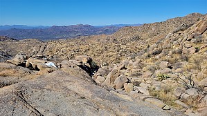
 Overview OverviewThis is a use-trail originating from Ballantine Cabin. Sedan access is via Ballantine Cabin & Corral or access 4WD via Pipeline Trail. The loop was more than likely created by motorcyclists. It does not appear to be used too frequently. 80-90% of this loop is extremely easy to follow. Hike With a GPS track, there will be no problems. Long pants are recommended. Currently, the majority of the claws on the catclaw have been stripped away from previous travelers. That said, even the minor instances will torture unprotected skin and seasons change. There are slight variations to complete the loop. If there is an ounce of an explorer in you, this bad boy has a few bells and whistles along the way.
Despite remarkable trail-like stretches, this is a route of use. We had no issues or falls along the route on our inaugural foray. There are steep grades that were more forgiving thanks to recent moisture. Despite recent cycle traffic, some of the cross-path locking-catclaw would have demanded blood without careful foot placement, pants, and favoring one side or twisting along the way. Water Seasonal creeks: Upper Pine Creek & Tributaries Synopsis The unique rock formations are the focal point. The 2005 Edge Complex & 2020 Bush fires have wiped out all but a tree or two. Check out the Official Route and Triplogs. Leave No Trace and +Add a Triplog after your hike to support this local community. One-Way Notice This hike is listed as One-Way. When hiking several trails on a single "hike", log it with a generic name that describes the hike. Then link the trails traveled, check out the example. | ||||||||||||||||||||||||||||||||||||||||||||||||||||||||||||||||||||||||||||||||||||||||||||||||||


