Route Editor

| Guide | ♦ | 2 Triplogs | 0 Topics |
details | drive | permit | forecast | route |
stats |
photos | triplogs | topics | location |
| 46 | 2 | 0 |
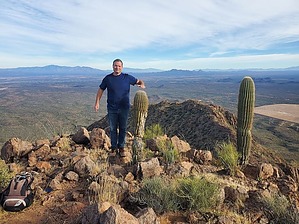
A bird's eye view of the mining operation by Mike_W  Overview OverviewSilver Bell Peak, elevation 4261, is the highest point in the Silver Bell mountains and is about 1 mile southeast of Silver Bell 4195, as the crow flies. From the top of Silver Bell Peak, you'll have a bird's eye view of the Silver Bell Mine below, and some nearby peaks including Ragged Top 2.8 miles north, Waterman Peak southsoutheast, and Picacho Peak 16.5 miles to the northeast. Hike From the guzzler near the parking area, hike west/northwest for about 1/2 mile crossing a few washes and gradually increasing in elevation. You'll want to keep ascending but stay north of the rocky ridgeline for roughly the first 1.8 to 1.9 miles to make the hike easier. After 1.8 to 1.9 miles you'll see a way to hike up to the rocky ridgeline. This is a good time to get on top of the ridge because otherwise, the hike can get very steep and perhaps dangerous.
From the peak, looking northwest, you'll be able to see Silver Bell 4195 which is roughly 1 mile away and only 66 feet lower in elevation. Looking down to the north, there's a pretty large rectangular structure on a saddle which is a guzzler. This catches rainwater and supplies a nearby pool which is available for the wildlife in the area. An alternate, perhaps easier, and more interesting route down from this peak is to head to the guzzler and then down the canyon going east. The canyon was slow going but fairly clear in early December. Sometimes you'll see a few different branches of the canyon and you can take the branch that has the least debris. There are a few areas where you'll need to climb down some large boulders. Sometimes there are 4 or 5-foot drops. But, the canyon was quite pleasant compared to areas of teddy-bear cholla and other desert brush that we saw outside the canyon. There wasn't any water in the canyon in December, but there definitely would be after the monsoon season. Hike for approximately 2.2 miles down the canyon. At this point, the terrain will be relatively flat. From here, turn right and start heading south/southeast toward the fenced-in guzzler and the road you came in on to complete the loop.
Check out the Official Route and Triplogs. Leave No Trace and +Add a Triplog after your hike to support this local community. | ||||||||||||||||||||||||||||||||||||||||||||||||||||||||||||||||||||||||||||||||||||||||||||||||