Route Editor

| Guide | ♦ | 3 Triplogs | 0 Topics |
details | drive | no permit | forecast | 🔥 route |
stats |
photos | triplogs | topics | location |
| 52 | 3 | 0 |
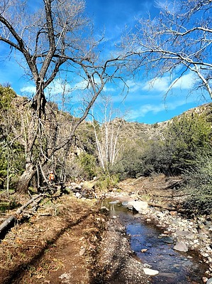
topography temptations by joebartels  Overview OverviewExperience upper South Fork of Sheep Creek. Rise quickly to a high point with excellent 5G. Return on a hint of use-trails to area springs. Hike From Mormon Grove Trailhead head up/east Saddle Mountain Trail #91 0.55-mi. This doubles as part of the Arizona Trail and is in excellent condition. Turn left/SW on Little Saddle Mountain Trail #244 and follow 1.25-mi. Intriguing geology at a shallow ravine is about 0.3-mi along this stretch.
At about 2.65-mi you cross the creek in dense forest and scrub. 3.5-miles in involves following the creek in earnest. The creek was lightly flowing on our inaugural journey, seemingly from the saturation of recent snowmelt. The unexpected situation raised spirits. Staying dry ducking, crawling over, and jumping the creek was fairly constant for 2-2.2 miles. There are a few flat aprons, bonus segments of use-trail and mesquite bosques. Creekside geology squeezed dry options out of the creekbed just before Tournament Creek. Which I thought resembled shorty-fatty narrows. Back a few dozen yards was a suitable exit out of the creek to ascend towards 4070. A steep c3 scramble minutes up raised concern but it was over quick. Albeit semi-intriguing, 4070 is easily passed on the right. 4642 looms above to the east with Saddle Mountain northeast. 4642 is a little intimidating at first. Concern fades midway up. Looking back oughta whet your appetite if there is an ounce of an explorer in you. We aimed for the right/south edge. It seemed like the best route and we saw a few white-tailed deer breeze up after planning on it. It gets steep in the final 100-ft or so. I hugged a few boulders for balance. Dry clumps of grass helped as handholds a few times too. There is a stack of rocks that appears intended for a register but was not easily found. We took a lunch break beside a nearby juniper because it was windy. Our return was staying right/south of 4977 aiming for Chalk Spring. We found cairns, stretches of use-trail and cut branches. Without preplanning, we did not take the easiest route back. Thanks to @hikerdw for sharing a route and based on the satellite view, you will have an easier return. We took a right turn to a bushwhack. Instead, stay left towards Marion Spring. The use-trail may be faint but is the obvious choice now. Synopsis Undesirable enough to keep most out. Accessible enough as one of the better mountain country options near the valley that isn't totally wiped out by fire. The 1995 Basin Fire blazed the west and the 2012 Sunflower Fire torched the east. South Fork of Sheep Creek was either slurried or sacrificed down in the creek. We didn't see any sign of bears but you'd be wise to keep them in mind if camping. 27-Second Youtube Video Check out the Official Route and Triplogs. Note This is a moderately difficult hike. Leave No Trace and +Add a Triplog after your hike to support this local community. | ||||||||||||||||||||||||||||||||||||||||||||||||||||||||||||||||||||||||||||||||||||||||||||||||||||||||