Route Editor

| Guide | ♦ | 1 Triplog | 0 Topics |
details | drive | permit | forecast | route |
stats |
photos | triplog | topics | location |
| 56 | 1 | 0 |
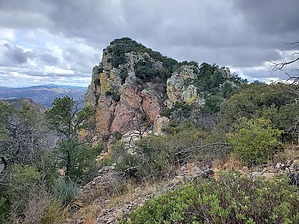
perhaps the arch is more "famous" than the peak by Mike_W  Overview OverviewRamanote Peak is in the Atascosa mountains, has an elevation of 6,032 feet, and is roughly 1.5 miles northeast as the crow flies from Atascosa peak, the highest point in the Atascosa mountains. Overall, it is a rough bushwhack, and I'd give this hike a difficulty of 5 out of 5. Most hikers will not be interested in summiting this peak, but the canyons in this area are quite pleasant if you can avoid the catclaw bush. There are a lot of cattle in the lower elevation areas which have grazed and made trails. You may also encounter migrant trails and some trash along the way to the peak. There's a natural arch in this area, called the Ramanote Natural Arch but it's on a different route from the route going to the peak.
In general, we were thankful for the many cow trails at the lower elevation because they saved us some time. Looking up toward the direction of the peak, we saw a rocky ridge that was blocking our view of the peak. This rocky ridge had a notch somewhere near the middle. We decided to head for this notch because it appeared to be the best route to the peak. The brush was pretty thick immediately below the notch, but once we got through that, the terrain opened up and flattened out a bit. We found trails that took us up higher in elevation that was used by border crossers and saw a lot of trash and debris along the way. Then, when we got closer to the high point, we climbed up a rocky area. Once at the high point, we realized we were at a false summit, and had to climb along a curved long rocky ridge to get to the peak. This curved rock ridge was at least 1/2 mile long. Near the peak, we happened to see multiple areas with a lot of blankets, trash, and debris. We were not sure how long it had been there. At the peak, we had some great views of Atascosa lookout and Atascosa peak. We looked all around for a registry but didn't find one. I happened to have a jar with me so I started a new registry in March 2023 and put it under a small rock pile at the high point. Our route going up was probably a better choice than our route going down. Our route going down followed a nice gradual ridgeline for probably 1.5 miles, but then we were forced to enter a canyon that was messy and required us to hike along the side of a steep canyon, which was tedious and time-consuming. Here's a rough narrative of the route that I posted. Ascent: ------- 0 - 0.18 miles - Follow Camino Ramanote Road west 0.18 - 0.36 miles - Follow an unmarked road going west 0.36 - 0.72 miles - bushwhack downhill, then head northwest to cross wash, follow cattle trails 0.72 - 1.6 miles - hike northwest and west to get a better view following cattle trails at times, then head toward "the notch" 1.6 - 1.7 miles - hike through the notch and continue UP 1.7 - 2.75 - continue following the wash to a point that can be crossed 2.75 - 2.97 - climb up a steep rocky area to a high point 2.97 - 3.5 - climb along the rocky ridge to the summit Descent: -------- 3.5 - 4.5 - follow the rocky ridge down to a gentler ridge. This part of the hike took a long time because of the steepness, rockiness, and rain. It was definitely a lot slower going down this route. We felt like we would have made better time on the same route we took up, had we taken it down. 4.5 - 6.0 - follow the gentler ridge down as far as we could go. There were some rocky and steep areas near the bottom, above the canyon. 6.0 - 6.32 - enter the canyon, stay on the left side of the canyon 6.32 - 7.09 - cross the canyon, follow cattle trails in the canyon, or on the right side of the canyon 7.09 - 7.51 - look for an old road going south, east, southeast, and then south again to the starting point Check out the Official Route and Triplog. Note This is a difficult hike. Arrive fit and prepared or this could get ugly. Leave No Trace and +Add a Triplog after your hike to support this local community. | |||||||||||||||||||||||||||||||||||||||||||||||||||||||||||||||||||||||||||||||||||||||||||||||