username
X
password
register
for free!
help
 This is likely a great time to hike this trail!  Check out "Preferred" months below, keep in mind this is an estimate. 
   🔥

Rice Peak Santa Rita Mountains, AZ

Guide 5 Triplogs  0 Topics
  3 of 5  
Fav
Wish
0
details
drive
permit
forecast
🔥
route  
stats
photos
triplogs
topics
location
0 5 0
Statistics
tap row or icons for details
Difficulty 1.5 of 5
Route Finding 2 of 5
Distance Round Trip 0.2 miles
Trailhead Elevation 9,106 feet
Elevation Gain 150 feet
Accumulated Gain 150 feet
Avg Time Round Trip 15-30 min
Kokopelli Seeds 0.95
 Interest Off-Trail Hiking, Seasonal Creek & Peak
feature photo
Photos Viewed All MineFollowing
Inaugural Calculation on Button Tap!
30  2025-06-21
The Rita Lode
chumley
39  2025-06-21
The Rita Lode
John10s
8  2023-11-14
Mount Ian
Jim
10  2023-04-15
Crest Trail #144 - Santa Rita Mtns
Jim
13  2022-06-04
Crest Trail #144 - Santa Rita Mtns
Jim
Author
author avatar Guides 16,843
Routes 17,472
Photos 24
Trips 1 map ( 6 miles )
Age 28 Male Gender
Location HAZ, TrailDEX
Co-Author
co-author avatarGuides 73
Routes 176
Photos 10,174
Trips 2,324 map (14,158 Miles)
Age 46 Male Gender
Location
Historical Weather
Trailhead Forecast
Radar Map
Expand Map
Preferred May, Jun, Sep, Oct → 7 AM
Sun  6:01am - 6:44pm
Official Route
 
3 Alternative
 
Historic Fire Perimeteracres
🔥 2005 Florida Fire23.2k


remove free decal offer
like blanco on arroz
by HAZ_Hikebot & Jim

 Likely In-Season! 
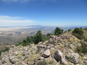
Rice Peak 9101' is an attractive and grassy summit just downslope from Mount Ian. It is a slightly nicer summit than Ian, but lower and so might see fewer people.


A short off-trail hike from the Crest Trail takes you to the top. When hiking north on the Crest Trail #144 from Baldy Saddle, leave the trail just past the aspen grove where you might leave to summit Mount Ian, in the mature forest of mostly Douglas-Fir, before you begin to encounter switchbacks. There is minimal dead-down material.

2023-04-19 HAZ_Hikebot & Jim


    Check out the Official Route and Triplogs.
    Leave No Trace and +Add a Triplog after your hike to support this local community.
    WARNING! Hiking and outdoor related sports can be dangerous. Be responsible and prepare for the trip. Study the area you are entering and plan accordingly. Dress for the current and unexpected weather changes. Take plenty of water. Never go alone. Make an itinerary with your plan(s), route(s), destination(s) and expected return time. Give your itinerary to trusted family and/or friends.

     Permit $$
    no fees or permits reported

    if incorrect tell us about it

    Coronado Forest
    MVUMs are rarely necessary to review unless mentioned in the description or directions
    Coronado Motor Vehicle Use Maps (MVUMs)


     Directions
    or
     Road
    Paved - Car Okay

    To hike
    Access is from the Santa Rita Crest Trail #144, https://hikearizona.com/decoder.php?ZTN=1380 see description for access. Multiple access options exist. Madera Canyon is most popular.
    page created by Jim on Apr 19 2023 1:36 pm
     90+° 8am - 6pm kills
    helpcorrectionissue

    end of page marker