Route Editor

| Guide | ♦ | 2 Triplogs | 0 Topics |
details | drive | permit | forecast | 🔥 route |
stats |
photos | triplogs | topics | location |
| 37 | 2 | 0 |
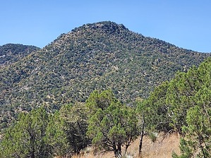
3,000 feet below Mt Wrightson by Mike_W   Overview OverviewDitch Mountain, with an elevation of 6,443 feet, is on the East side of the Santa Rita mountain range and is accessible from the well-maintained Arizona Trail. The nearest major trailheads are the Cave Canyon trailhead and the Tunnel Spring trailhead. The hike involves 1.3 miles round trip of bushwhack up/down a ridgeline to the peak that gets a bit steep at the top, and several miles of nice Arizona trail with some rocky 4x4 road, depending on which trailhead you start from. History I've used my phone to extract this text from a sign on the Arizona trail South of the Tunnel Spring trailhead:
Scarce Resources: Water and Gold Step back in time..... This section of Arizona Trail follows a water system built a century ago for a short-lived hydraulic mining venture. In hydraulic mining, powerful jets of water blast away hillsides to reach gold deposits But in the Santa Rita Mountains gold deposits and ample water do not occur in the same valleys. In 1904 the Santa Rita Water & Mining Company built ditches, pipes, and tunnels to carry water from streams and springs near here to the dry, gold-bearing gravels near Greaterville. Here, a tunnel nearly 1,000 feet in length connected a ditch in Big Casa Blanca with Gardner Canyon and the rest of the water system. As you hike north along the trail, signs will point out features of this system. A ditch carried water 2½ miles from Big Casa Blanca Canyon to this tunnel entrance. Now, the boarded-up tunnel Impounds underground water. Hike Start at the Link and Cave Canyon trailhead which is in Cave Creek Canyon and hike West/Southwest following the Link trail which heads uphill. Take this trail roughly 0.75 until you reach a road, which I believe is called FS 785. Follow the road downhill for roughly 1 mile until you reach the Tunnel Spring trailhead. If you were able to drive to this point, you could start your hike here. At the Tunnel Spring trailhead, which is in Gardner Canyon, this junction is where you merge into the Walker Canyon trail which is part of the Arizona trail. Continue along the Arizona trail for 1.7 miles until you reach the ridge that is Northeast of Ditch Mountain. This part of the trail is relatively flat. You should be able to look South/Southwest and see the top of Ditch Mountain. You will want to hike off the Arizona Trail climbing North at about this point to get on the ridge that leads up to the summit of Ditch mountain. It may be a bit steep getting up to the ridge, then once on the ridge, the hiking will be a little easier. You should be able to wind through the oak and pine trees, heading West toward the summit. There are a few tricky areas, but if you stay in the middle of the ridge you can follow it up to the peak. At the peak, there were excellent views of Mt Wrightson, Mt Ian, Florida Saddle, and the entire high ridgeline of the Santa Rita mountains. You'll see a registry at the top under a rock pile. At the peak, there were also some nice oak and pine trees with some shady areas. Check out the Official Route and Triplogs. Leave No Trace and +Add a Triplog after your hike to support this local community. | |||||||||||||||||||||||||||||||||||||||||||||||||||||||||||||||||||||||||||||||||||||||||||||||||||||