Route Editor

| Guide | ♦ | 2 Triplogs | 0 Topics |
details | drive | permit | forecast | 🔥 route |
stats |
photos | triplogs | topics | location |
| 16 | 2 | 0 |
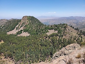
raise the bar by Mike_W   Overview OverviewBarfoot Peak is in the Chiricahuas mountains, at an elevation of 8,803 feet. It's a short but challenging bushwhack with some steep areas, some scrambling, and can be accomplished in roughly 2 hours by an experienced hiker. Hike Start from the Barfoot Park area and walk up the road for roughly 0.2 miles or more depending on your starting point. When the road curves to the right you will see a good place to get off the road on the left side. Turn left here and climb up a gradual slope aiming for the east ridgeline. From here I started climbing up the steep slope to the high point above me. There were a few fallen trees to go around or step over. I reached a high point which was east of Barfoot Peak. It was very rocky and brushy, but I was able to squeeze by and continue working my way toward Barfoot Peak.
Within a few minutes of leaving the summit, heading west, I reached an area where I had to go down and cross over a large patch of scree. It looked much worse than it was. I found the rock to be fairly easy to walk across because of the larger pieces. But, these rocks are loose, so it's important to be careful here to avoid an ankle sprain. I took my time and reached the saddle to the west after about 20 minutes. After getting to the saddle, it appeared that I was off the rocky section and I could relax a bit. From here, the terrain was dirt with a mixture of grass and rocks. Although very steep going down, I was able to zig-zag downward without slipping. At times I found some animal trails but there was nothing that continued going down. I followed sections of animal trails and took it step by step until I reached the bottom. Near the bottom, I was able to see a picnic area, and metal axles/wheels, so I already knew exactly where I was. Then, I climbed back up the hill to get back to my campsite. Check out the Official Route and Triplogs. Leave No Trace and +Add a Triplog after your hike to support this local community. | |||||||||||||||||||||||||||||||||||||||||||||||||||||||||||||||||||||||||||||||||||||||||||||||||