Route Editor

| Guide | ♦ | 1 Triplog | 0 Topics |
details | drive | permit | forecast | 🔥 route |
stats |
photos | triplog | topics | location |
| 16 | 1 | 0 |
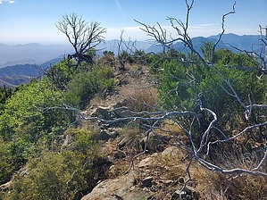
Spice it up! by Mike_W   Overview OverviewOnion Peak, in the Chiricahua Mountains, is at an elevation of 8,022 feet and involves a 0.8-mile hike up a combination of a good 4x4 road and a good trail. Then, about 1/3 of a mile of bushwhack along a ridge to get to the summit. For part of the bushwhack, you'll be able to follow a fence line, but you will need to go around some obstacles in various areas. Hike Start at Onion Saddle, which is at roughly 7,600 feet elevation. From here you will hike north on FS 4856. After 0.46 miles you will see a primitive doorway on the right side of the road that I assume is to keep cattle or other animals out. Cross through this doorway and continue to follow the Shaw Peak trail #251 up the ridge until you have hiked a total of roughly 0.8 miles.
At the top, you'll find a registry in a rock pile. This peak appears to only get 1 or 2 groups of hikers per year. Looking north, you should have some great views of Cochise Head in the distance. Looking north/northwest about 2.5 miles away, you should see 3 high points that are pretty close together. The 2 left-most high points are much closer together than the peak to the right. I believe the middle peak is Shaw Peak, which is over 40 feet lower than the left-most peak. It's a bit odd that the topo map labeled the lower peak as Shaw Peak, but not the taller peak south of Shaw. I'll write a guide for Shaw Peak someday. Follow the same route back to complete your hike. Check out the Official Route and Triplog. Leave No Trace and +Add a Triplog after your hike to support this local community. | |||||||||||||||||||||||||||||||||||||||||||||||||||||||||||||||||||||||||||||||||||||||||||||||||||||