username
X
password
register
for free!
help
 This is likely a great time to hike this trail!  Check out "Preferred" months below, keep in mind this is an estimate. 
   🔥

Peak 8146 - Catalinas, AZ

Guide 3 Triplogs  0 Topics
  4 of 5  
Fav
Wish
0
details
drive
permit
forecast
🔥
route  
stats
photos
triplogs
topics
location
115 3 0
Statistics
tap row or icons for details
Difficulty 3 of 5
Route Finding 2 of 5
Distance Round Trip 2.7 miles
Trailhead Elevation 7,731 feet
Elevation Gain 422 feet
Accumulated Gain 542 feet
Avg Time Round Trip 1.5 hours
Kokopelli Seeds 5.41
 Interest Off-Trail Hiking & Peak
 Backpack Possible - Not Popular
unreported if dogs are allowed
editedit > ops > dogs to adjust
feature photo
Photos Viewed All MineFollowing
Inaugural Calculation on Button Tap!
17  2024-09-28 Mike_W
49  2024-06-29 Mike_W
49  2023-07-08 Mike_W
Author
author avatar Guides 104
Routes 256
Photos 16,118
Trips 528 map ( 2,863 miles )
Age 53 Male Gender
Location Tucson, AZ
Historical Weather
Trailhead Forecast
Radar Map
Expand Map
Preferred Apr, May, Sep, Oct → 9 AM
Seasons   Spring to Autumn
Sun  6:00am - 6:42pm
Official Route
 
0 Alternative
 
Historic Fire Perimetersacres
🔥 2020 Bighorn Fire119.5k
🔥 2003 Aspen Fire87.7 mi*
🔥 2002 Bullock46.8 mi*
🔥 View (All) - over Official Route 🔥
*perimeter length in miles


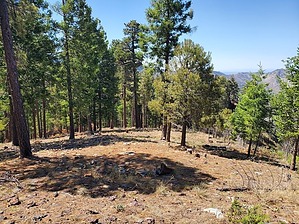
This peak needs a better name... Little Bigelow? Bear Wallow peak?
by Mike_W

 Likely In-Season! 
Overview
Peak 8146, in the Catalinas, is only 1-mile northwest of Mt Bigelow, as the crow flies. There's no trail going to the top, but various roads and trails will get you to the base of this peak. It's a fairly steep hike to the top, but it's a short hike. From the peak, there are some nice views looking to the north toward Oracle Ridge.


Hike
From the Sunset Trailhead, hike South and you will see a trail that curves around and goes downhill. You will cross a bridge going over a stream, then turn left. This trail will follow the road for a while and there's a lot of shade and tree cover. After hiking about 2/3 of a mile, the trail will go under Mt Lemmon highway. After about 0.8 miles you will see a trail leading left up to a road. You will want to stay on the trail and not exit to the road (yet). You'll see a few campsites in this area. Continue until you have traveled a total of 1.05 miles. At this point you should be very close to a road, take one of the many trails leading up to the road. You should be pretty close to this point.
remove free decal offer
Within 100 feet or less of this point, you should see a cluttered canyon heading east. You will see a lot of downed trees and possibly an old faint trail that goes up the canyon. Peak 8146 is north of this canyon. Instead of taking the old and probably abandoned trail, I found it easier to climb up the side of Peak 8146. It will be quite steep but you can weave left and right to cut down on the steepness. At times you may see some animal trails that will help make the climb easier. Within a short time, you will be on the peak. At the peak, you will have nice views to the north, despite the burned trees that you will see. You will also be able to see Oracle Ridge. Looking east, you should see the antennas on Mt Bigelow.

To get down, it will be easier to head northwest, as the slope will be easier. When you get near the bottom, you will see a cabin down below which is on private property. There are no signs marking the property line, but I would recommend staying at least 100 feet away just to give anyone space who may be there. Once you reach the road, that is not on private property and you can take this road downhill to a junction. Once at the junction, take a right and then look for a trail heading down to the trail that you were on earlier. Take this trail down and you should be on the same trail you were on previously, which you will use to get back to the trailhead. From here, it's just under 1 mile to get back to the Sunset trailhead.

2023-07-10 Mike_W


    Check out the Official Route and Triplogs.
    Leave No Trace and +Add a Triplog after your hike to support this local community.
    WARNING! Hiking and outdoor related sports can be dangerous. Be responsible and prepare for the trip. Study the area you are entering and plan accordingly. Dress for the current and unexpected weather changes. Take plenty of water. Never go alone. Make an itinerary with your plan(s), route(s), destination(s) and expected return time. Give your itinerary to trusted family and/or friends.

     Permit $$
    None

    Coronado Forest
    MVUMs are rarely necessary to review unless mentioned in the description or directions
    Coronado Motor Vehicle Use Maps (MVUMs)


     Directions
    or
     Road
    Paved - Car Okay

    To hike
    From Tucson, take Tanque Verde Rd going east to Catalina Highway.
    Use the left 2 lanes to turn left onto E Catalina Hwy.
    4.5 mi

    Continue onto E Mt Lemmon Hwy
    22.6 mi

    Turn left onto Soldiers Camp Rd (the same place as the Sunset Trailhead, which is also just past the Butterfly Trailhead, but on the left side of the road).
    62 ft

    Soldiers Camp Rd / Sunset trailhead
    Mt Lemmon, AZ 85619
    page created by Mike_W on Jul 10 2023 10:44 pm
     90+° 8am - 6pm kills
    helpcorrectionissue

    end of page marker