For the Time Being, a Trail to Nothing by pseudalpine
Overview
Essentially a connector trail to nothing, but consequently, there may be a plan to change this in the future. If that does happen, this guide can easily be edited by the man, the myth, the legend, to reflect current conditions on the ground.
Hike
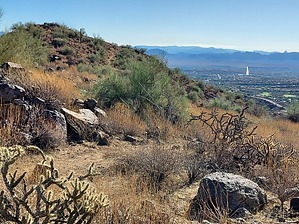
Approached from the north via the Dixie Mine TH at Eagles Nest or more likely from the Adero Canyon TH via the Promenade Trail - FHP. It really is an easy down and back to the terminus near one of Fountain Hills' water tanks. I'd guess it's probably a somewhat challenging mountain bike ride, but they're not allowed. In its current form, it really is a similar trek as the humdrum of the Sonoran and/or Lower Sonoran trails.
Sidenote
If one reviews the trail options on page three of that Fountain Hills McDowell Mountain Preserve 2022 Master Plan, a proposed Quartz Trail Connector, IMHO would be a great addition. Especially considering that the Quartz Trail - MSP also essentially goes nowhere. Completing that connector would open up some great loops.
WARNING! Hiking and outdoor related sports can be dangerous. Be responsible and prepare for the trip. Study the area you are entering and plan accordingly. Dress for the current and unexpected weather changes. Take plenty of water. Never go alone. Make an itinerary with your plan(s), route(s), destination(s) and expected return time. Give your itinerary to trusted family and/or friends.
Permit $$
None
Directions
Road
Connector trail - Not Applicable
To Adero Canyon Trailhead From Loop 101 and Shea Blvd head east on Shea Blvd for 7.8 miles. Then turn left on N Palisades Blvd and continue 1.1 miles. Turn left at the stop sign onto Eagle Ridge Drive and continue 2.4 miles until you reach the Adero Canyon Trailhead. Note that along the way Eagle Ridge Drive first becomes N 143rd Way and then becomes N Eagle Ridge Drive.
• February 2019: There is road construction on Eagle Ridge Dr, and the last mile to the trailhead is on a well-graded, unpaved road. However, that section of the road will ultimately be paved.
• January 2020 FHP writes: Fountain Hills (Parks & Wildlife Dept..480-816-5100): Adero Cyn TH/Parking is presently "only" accessible for parking access at the closed chain link fence ~1 mile "prior-to" TH Parking on N. Eagle Ridge Drive. M-F Trailhead access from ~1 mile up road is only legal from 3pm daily. Sat & Sun TH access from ~1 mile up road is legal from dawn to dusk.
• 2020-02-15 Yoder writes: Road to trailhead parking is closed due to construction. You may want to go to the Sunrise Trailhead parking. • 2020-11-09 Grasshopper writes: Officially opened, and the road to the Parking / TH is now paved.
From PHX (I-10 & AZ-51) 43 min (32.3 miles) From TUC (Jct 1-10 & Grant) 2 h 7 min (131 miles) From FLG (Jct I-17 & I-40) 2 h 28 min (155 miles)
page created by pseudalpine on Feb 02 2024 12:14 pm
 Route Editor

 Overview