Route Editor

| Guide | ♦ | 1 Triplog | 0 Topics |
details | drive | permit | forecast | route |
stats |
photos | triplog | topics | location |
| 44 | 1 | 0 |
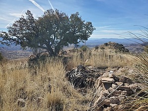
gateway to the Santa Ritas from the South by Mike_W  Overview OverviewSanta Rita Peak, which is also known as Squaw Peak on historical topo maps, is at an elevation of 5,761 in the southern Santa Rita Mountains. There are rolling hills and cattle graze all over this area, which makes hiking easier. This is classified as an open country hike as there are not many obstacles to go around. To the east and southeast is Santa Rita Gulch which had some running streams in late January and seemed to be an ideal place for wildlife and raising cattle. Hike Whether you drive or walk on FS 144, this is how you will want to proceed, going north/northeast. From the FS 143 junction, you will want to continue for 0.9 miles on FS 144.
I kept going up the ridgeline and noticed there were 2 high points with the official peak being the northern peak and that's where the registry was. The topo map labeled the peak as the southern-most peak and I didn't see anything there. At the slightly higher peak where the registry was, there were a few oak trees and evidence that cattle had been way up there. They are great climbers, those cattle. From the top, looking north, I was able to see the top of Mt Wrightson with snow cover in January. I was also able to see Mt Hopkins and the observatory which was left of Wrightson from this perspective. On the way down, I decided to follow a different ridgeline going east/southeast and heard some cattle noises in the distance. When I got lower I saw an area with free-range cattle behind a gated area. I walked into the gated area just to check it out. I saw a stream and a tank in this area. There were many cows and calves. Most of them walked away from me and I heard some noises in the distance that sounded like the bulls were quite angry at me. Maybe they were being protective of the females and the calves. Anyway, I didn't stay long and walked FS 144 back to where I parked. Gate Policy: If a gate is closed upon arrival, leave it closed after you go through. If it is open, leave it open. Leaving a closed gate open may put cattle in danger. Closing an open gate may cut them off from water. Please be respectful, leave gates as found. The exception is signage on the gate directing you otherwise. Check out the Official Route and Triplog. Leave No Trace and +Add a Triplog after your hike to support this local community. | |||||||||||||||||||||||||||||||||||||||||||||||||||||||||||||||||||||||||||||||||||||||||||||||