 Route Editor

| Guide | ♦ | 3 Triplogs | 0 Topics |
details | drive | no permit | forecast | 🔥 route |
stats |
photos | triplogs | topics | location |
| 9 | 3 | 0 |
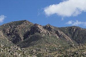
Almost Grand Canyonesque?! by pseudalpine  Overview OverviewBelow and southwest of Boulder Mountain's main western 6320’ summit and at an elevation of approximately 5600 to 5800 feet, the southwestern prow of the Whorled Wall is coined A-frame with the other primary orientations being the west and south faces. This is just one crag of a series of granite bluffs, boulders, domes, ridges, and walls in the Tonto National Forest at the far southern end of the Mazatzal Mountains. Many of the climbing routes are concentrated on the south side of the highest western summit, which is one of four main crests that stretch westward greater than two miles from the Mazatzal Divide. This delimitation separating Gila and Maricopa counties is distinctly noticeable looking east from the Beeline Highway where Sycamore Creek crosses at Round Valley, significantly higher and southeast from Sycamore Wall, Crabtree Butte, and Boulder Pass (Boulder Bobs Cabin). Hike The main approach is arduous, reminiscent of the obligatory struggle accessing some of the routes found in a few other Arizona backcountry climbing areas, e.g. Sedona, the Supes, and Grand Canyon. That is the only similarity, as the resemblance ends there because this is really just another crag with mostly single pitch routes. Regardless, the analogous remoteness and mostly worthy, unclimbed Xg granite may justify the gumption for some. There are at least two alternative approaches, one being FR 1704 (4x4) from Round Valley (near The Colony) that becomes undrivable at ~3350' below the Boulder Mountain Spring and the second is an insane motorcycle route from SR87 south of Round Valley that accesses upper Pine Creek (likely an original wrangler route).
There’s a cowboy cabin, a water tank, and a corral in the basin before the path widens to an old jeep road. An approach to the main areas follows the Pipeline Trail north towards Mud Springs for about another 0.7 miles and then leaves the old road, generally bearing northeast, ascending through a few Chaparral benches. If you’re on route, you’ll pass over a saddle and descend onto a large, slightly upsloping bajada. You’ll be able to see much of the main summit granite from this tilted bench. At the northeast end, it’s difficult to avoid bushwhacking the drainage, but once through, the vegetation becomes less dense (this has probably changed since the Bush Fire). Turn more east, ascending south of benchmark 4879’, and then skirt the west side of another hill before ascending the last steep slope. The off-trail segment up to the base of the Whorled Wall etc. is ~1.8 miles and ascends ~2100’. The total estimated approach distance from SR87 is ~6¼ miles and +3510’… not quite Grand Canyonesque. Synopsis The crags in this area have a limited climbing window, since it's balls hot at least six months of the year, rattlers galore in the fall and spring and Aves roosting on the higher elevation cliffs some of the remaining good months. Check out the Official Route and Triplogs. Leave No Trace and +Add a Triplog after your climb trip to support this local community. | ||||||||||||||||||||||||||||||||||||||||||||||||||||||||||||||||||||||||||||||||||||||||||
 Rated
Rated


