 Route Editor

| Guide | ♦ | 1 Triplog | 0 Topics |
details | drive | no permit | forecast | route |
stats |
photos | triplog | topics | location |
| 0 | 1 | 0 |
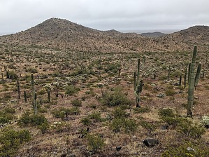
Curving & Circling the CGM Cacti by pseudalpine  Overview OverviewThis is one of the shorter interior Casa Grande Mountain Park trails that also passes through some stately Saguaros and provides access to the nearby Chain Cholla Forest Trail. Visitors will likely approach this area from the eastern Arica Road or southern Henness Road Trailheads via the East or West Butte Trails. The Ridge Trail would also be a logical approach option. Hike The official route splits off the West Butte Trail bearing southwest and then sweeps through three turns before reaching the northern Chain Cholla Forest Trail junction at a quarter mile. The trail then bears east for a bit, stays right at the Social Trail Green 0.26, and then turns south to rejoin the Chain Cholla Forest Trail. From this southern end, one may merge with the West Butte Trail by hiking a bit more south or return to it at the original location by looping back via the obscure Chain Cholla Forest Trail.
This easy connector trail is likely to be completed as a loop with the adjacent Chain Cholla Forest Trail, but it's also a decent West Butte Trail connector.
Check out the Official Route and Triplog. Leave No Trace and +Add a Triplog after your hike to support this local community. One-Way Notice This hike is listed as One-Way. When hiking several trails on a single "hike", log it with a generic name that describes the hike. Then link the trails traveled, check out the example. | ||||||||||||||||||||||||||||||||||||||||||||||||||||||||||||||||||||||||||||||||||||||


