Route Editor

| Guide | ♦ | 5 Triplogs | 0 Topics |
details | drive | no permit | forecast | 🔥 route |
stats |
photos | triplogs | topics | location |
| 128 | 5 | 0 |
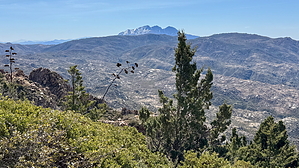
Don't be a shy pebble, be a little boulder! by chumley  Overview OverviewThis mountain stands between the commonly recognizable Four Peaks and Mt. Ord in the southern half of the Mazatzal Mountains. There is no trail. This summit can be reached from several directions, but this is the most common and direct non-technical approach. Hike While there is no established route to the summit of Boulder Mountain, the best way to access the summit begins from Round Valley along the Beeline Highway. Forest Road 1704 leads from the highway across Sycamore Creek and through a maze of spur roads and dispersed campsites before consolidating into a defined two-track that heads uphill about half a mile from the start. This is definitely a "jeep road". A capable vehicle paired with an experienced driver can drive much of this road, but this description assumes most will walk the road -- mostly because it would not save much (if any) time to attempt to drive it.
Once reaching the initial crest, great views of Four Peaks and the Superstitions to the south present views that justify the effort to reach this point but the actual high point of Boulder Mountain stands a short distance east where you will find a large cairn and summit register. Getting there might involve fighting some stout manzanita and no obvious use path. It's not technically enjoyable, but it also doesn't last too long. :) From Round Valley this is close to a 4,000 foot climb, less than 2 miles of which is not on rough 2-track. But not a lot of social influencer types will ever want to do this, which might make it more interesting to others. Connecting Options From the high point, you can return the way you came, or you can traverse the full ridgeline (plan on 2-3 hours) across to Forest Road 422 north of Little Pine Flat (which is also part of the Arizona Trail). Heading south will open options with the Ballantine Trail and north will bring you down toward Sunflower on the AZT. The Pipeline Trail and Boulder Bob's Cabin Trail provide possible routes to make long loops (20+ miles). Check out the Official Route and Triplogs. Note This is a moderately difficult hike. Leave No Trace and +Add a Triplog after your hike to support this local community. | ||||||||||||||||||||||||||||||||||||||||||||||||||||||||||||||||||||||||||||||||||||||||||||||||||||||