Route Editor

| Guide | ♦ | 1 Triplog | 0 Topics |
details | drive | no permit | forecast | 🔥 route |
stats |
photos | triplog | topics | location |
| 93 | 1 | 0 |
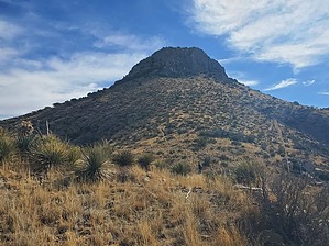
There are no sporting events played inside this dome! by Mike_W  Overview OverviewHelen's Dome is in the Northern Chiricahua Mountains very close to Fort Bowie National Historic Site. It has an elevation of 6,376 feet and is quite interesting because from a distance it looks like a huge rock dome that seems very difficult to climb. Luckily there is a hiker's route to the top that involves a few class 3 climbing areas. If you're interested in US history or want to see some historical sites, you may want to combine the Fort Bowie Loop with this hike, which is an easy 3-mile loop through the old historic town. Both hikes together would be about 9.5 miles round trip total.
There is another rock formation called Helen's Dome near Mica Mountain in the Rincon mountains which is a completely separate area and probably lesser known. There are other "dome" hikes in Southern Arizona, and this once reminded me of Mt Bruce, near Sonoita, AZ, which I also wrote a guide for. Helen's Dome had a slightly more difficult climbing section in comparison in my opinion. Hike Park at the Fort Bowie loop trailhead to start this hike. The Fort Bowie loop starts here and is a 3-mile scenic loop with historic sites to see. The hike to Helen's Dome is a round trip of 7 miles, and you can decide if you want to combine these hikes for a full-day adventure. From the trailhead, we followed the Ft Bowie loop trail for roughly 0.75 miles, then we turned right on the Butterfield trail and continued for about 0.6 miles. As I understand it, the Butterfield trail was an old postal courier route. Up to this point, the trails were in great condition and well-maintained. Next, it was time to get off the trail and walk the ridgeline toward Helens Dome. We were not sure what to expect. We found many use-trails which made the hike easier than we thought and fairly fast-moving. We hiked up a steep ridgeline for the next 0.6-mile segment and headed to the right to a saddle. At the saddle, there was a barbed wire fence which we had to crawl under. After crossing the fence we had a pretty clear view of the summit. From here we hiked southwest going up a steep slope and our goal was to get on the ridgeline heading toward the peak. It was not necessary to summit the peak to our southwest. All we needed to do was curve around to the left of it. Once on the main ridgeline, we found a use-trail heading in the direction of Helens Dome. The trail took us to another barbed wire fence where we stepped over a low area. Next, we kept following the use trail toward the peak. We knew we needed to summit from the southwest side of Helens Dome based on previous routes. It was quite steep getting to the base of the dome. Once there we curved around to the right (southwest side) and found a single cairn in a channel leading up. We were able to climb the channel, then turn right in front of a pine tree, then climb up from there. In this area, a little higher up we saw a cairn and then found a way to the summit. It was a bit tricky and we didn't go down the same exact way we went up. There are a few safe ways in my opinion and MANY dangerous ways. It wasn't very obvious where to go but we found a way that we knew we could handle. On the way up, we ended up needing to do a chimney climb up 2 opposing rock surfaces that were about 3 feet apart. We felt safe because there were good foot and hand holds and quickly made it to the next level where we were only 50 feet from the summit which was just a walk-up. At the summit, we could see the higher Bowie peak and down below the historic old town of Bowie. Be sure to remember where you came from. It's hard to lose your orientation at the summit. We found a registry left by a Boy Scout troop around 1975 which was still there. The oldest entry we found was from about 1970 and the pages were very faded and weathered. Those Boy Scouts back then we pretty tough. I was a boy scout in NY state and we never did anything close to this! You can hike the same way down and back to the trailhead, or if you'd like to see some of the historic sites, you could take a shortcut, which we did. Hike back down to the low saddle and the first barbed wire fence that you encountered. To the east of this saddle is peak 5572. Instead of crossing the barbed wire fence, stay to the right of the fence, summit peak 5572, and hike down the ridgeline into the historic area. There are some steep sections and rocky areas that you can hike around. You'll be able to see the old cemetery at the bottom. Hike down to the cemetery and enter through the opening on the north end. Right at this opening is the junction of the Ft Bowie Loop trail. From here you can hike east to get to the Apache Spring, old ruins, the Visitor's Center, and other sites. You can hike north to get back to the trailhead. See my trip log for more details about our adventure. Check out the Official Route and Triplog. Leave No Trace and +Add a Triplog after your hike to support this local community. | ||||||||||||||||||||||||||||||||||||||||||||||||||||||||||||||||||||||||||||||||||||||||||||||