 Route Editor

| Guide | ♦ | 7 Triplogs | 1 Topic |
details | drive | permit | forecast | 🔥 route |
stats |
photos | triplogs | topic | location |
| 50 | 7 | 1 |
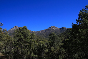
Don't drive to this trail, hike to it! by fricknaley  Overview OverviewJosephine Canyon Trail #133 is a relatively lesser traveled trail down the large, lush southern namesake canyon leading away from Josephine Saddle. The lower trailhead is a little nondescript pull-out along a long, rough FSR in the middle of nowhere. The upper trailhead is much more accessible, though it does require a hike to Josephine Saddle to reach. The shortest, most direct route is a roughly 1690 foot, 2.2-mile climb up the lower section of the Old Baldy trail. Since the Old Baldy trail is well known and well documented here on HAZ, I will not redescribe it for this guide. During wetter times of the year, this canyon bottom will have some water and cascading little falls.
From the signed Josephine Saddle, find the old metal sign pointing the way to Josephine Canyon Trail and Josephine Canyon Road, which heads south and down from the saddle. The upper part of the trail is narrow and slightly overgrown as it initially hugs the western wall, then crosses over to the eastern wall of upper Josephine Canyon. The initial descent is pretty steep, but soon thereafter, though steady, it becomes much less severe. Within 1/4 to 1/3 mile, the trail quickly breaks away from the canyon and takes a short ramble through a beautiful short stretch of pine forest before dropping back to the canyon eastern wall again. Here it drops down closer to the canyon bottom, which it hugs for about 0.5 miles, making some random crossings here and there. When the trail drops down to the creek bottom, it can sometimes be hard to follow. Look for cairns and the narrow path, and you should be able to pick it up again. The trail breaks right or west out of the canyon again for about 0.4 miles cutting through some additional excellent forest before returning to the creek bed one last time with some more random creek crossings. In a total of about 2 miles from the upper trailhead, you will come to the remains of some old stone building, with parts of a couple of walls still left in place. Before long, you are west of the canyon again and cutting through some scrub forest before popping out on an old overgrown dirt road. About 1/2 mile on this old road drops you off at the extremely nondescript little pull-out off FSR 4082, where the lower trailhead is located. An old small Santa Rita-style metal sign indicates the trailhead placed directly in the middle of a manzanita that you couldn't possibly find if you were looking for it off the FSR. The return route is the way you came. The first 1/2 mile back on the old overgrown road will now allow you some spectacular views of Mt. Wrightson's southern face and its neighbor, Josephine Peak. Please pay attention to the creek crossings on the way back; it can be a little tricky picking your route back up. Finally, note that this trail sees some illegal/border crossing activity. Bear this in mind when planning a trip here. I saw nothing out of the ordinary on this day other than a couple of water bottles. Coronado FS Details This trail not only provides a great hike, but the drive to the trailhead is well worth taking in its own right. It leads through scenic countryside, steeped in history, and dotted with ranches, mines, and ghost towns. The temptation is great to do a lot of exploring along the way, but the signs that tell you not to trespass are serious. Look and enjoy and keep on driving. Once you get to the Josephine Canyon Trail, you should be primed for a great trip and you won't be disappointed. The trail follows Josephine Creek for much of its length and, if the creek is running, you'll be treated to waterfalls and cascades flowing through a riparian area lush with greenery. Keep an eye out for nature's residents here. Deer are quite plentiful in the area and usually cooperate by remaining watchable still. Other animals you might see among the grapevines and sycamores include javelina, coatimundi, and, of course, the members of the diverse songbird population for which the Santa Ritas are famous. The trail steepens as the canyon climbs the mountainside, with an occasional switchback thrown in for good measure. Mt. Wrightson and Josephine Saddle loom larger on the horizon as you get closer to them, while Mt. Hopkins, with its alabaster observatory shining in the sun, dominates the view to the west. As you near Josephine Saddle, turn around and look at the canyon you've just traveled through as it frames good views of the Sonoita area and the Patagonia Mountains. Once you reach Josephine Saddle, you can choose from a number of trails that lead to the summit of Mt. Wrightson, or into Madera Canyon or Temporal Gulch. 2.3 miles of this trail are within the Mt. Wrightson Wilderness Mechanized vehicles, including mountain bikes, are not permitted in Wilderness. Check out the Official Route and Triplogs. Leave No Trace and +Add a Triplog after your hike to support this local community. One-Way Notice This hike is listed as One-Way. When hiking several trails on a single "hike", log it with a generic name that describes the hike. Then link the trails traveled, check out the example. | ||||||||||||||||||||||||||||||||||||||||||||||||||||||||||||||||||||||||||||||||||||||||||||||||||||||


