Route Editor

| Guide | ♦ | 12 Triplogs | 0 Topics |
details | drive | no permit | forecast | route |
stats |
photos | triplogs | topics | location |
| 76 | 12 | 0 |
Canyons are inherently risky. Flash floods occur without notice on sunny days. Technical skills & surrounding topography knowledge required yet does not eliminate risk.
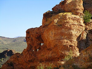
Sure To Heal What Ails Ya by AZLOT69  History HistoryNatural arches have meant different things to different people over the millennia. Many Indian cultures regarded them as religious shrines and if they did not feel they knew the appropriate words to appease the gods they would avoid them. Some civilizations thought it was a window to the next dimension and the departed would leave this way. Still, others have felt that passing someone thru the arch could cure what ails you, and simply passing thru the arch would leave you clean and healthy. Euro-Americans have found natural arches something to be admired. Overview This hike is an off-trail bushwhack to the arches and beyond taking in the peak of the monolith Golden Eye. Long sleeves and long pants are a plus.
The trailhead is accessed off the Golden Eye Mine Trail and from the east via the Gold Eagles Nugget Trail or Javelina Mine Trail. The trailhead is 0.4 miles west of the intersection Of Gold Eagles Nugget Trail and the Javelina Mine Trail. It is just east of a deep wash the Golden Eye Mine Trail passes thru which is the drainage for the V-shaped canyon on the monolith Golden Eye. It can also be accessed from the west via the Willow Springs Basin Tank Trail. From the trailhead, you can see what appears to be three arches on the left side of a V-shaped canyon on the monolith Golden Eye. Stay east of the canyon wash, working your way thru the brush which is not bad. As you get tight to the mountain follow the contour around to the right eventually getting into the wash. There are plenty of alcoves, diggings, and attractive rocks to distract you. Looking up you will see the arches are now out of sight. Follow the wash up the canyon. Eventually, boulders will dictate going out of the wash on the right side. There is some pretty healthy brush to push thru but mainly jojoba, so they will let you pass. Soon the arches reappear and surprise there are four. It appears that in time these four will become one large arch. There is an interesting canyon on the north side of the arch leading to a peak worthy of bagging. Back down at the arch continue up the canyon to the left. There are nice views of the arches now behind you. The top of this monolith is nothing like you would expect. Cubby holes abound, what a great place to hide out or play hide and seek. Mark your route exploring and return the way you came. Check out the Official Route and Triplogs. Leave No Trace and +Add a Triplog after your canyon trip to support this local community. | |||||||||||||||||||||||||||||||||||||||||||||||||||||||||||||||||||||||||||||||||||||||||||||||||||||||||||||||||||||||||||||||||||||||||||||||||||||||||||||||||||||||||||||||||||||||||||||