 Route Editor

| Guide | ♦ | 34 Triplogs | 2 Topics |
details | drive | permit | forecast | 🔥 route |
stats |
photos | triplogs | topics | location |
| 469 | 34 | 2 |
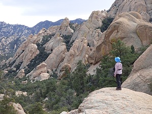
unique character by nonot  Warning WarningThis area was significantly impacted by the Pinnacle Wildfire in the summer of 2021. Even before the fire, the trail was significantly overgrown and in short stretches had already begun to disappear. Poor trail conditions should be anticipated. Overview A gentle descent to Black Rock Creek via the Holdout Creek Basin, taking you into the heart of the Santa Teresa Wilderness.
From Reef Tank, the trail proceeds eastwards beginning a gentle descent into the upper basin of Holdout Creek. The upper basin is spotted with Junipers and shrubbery, and is characterized by fine gravel on top of rocky slabs. The best aspect of this trail really hits you after about 1.5 miles, where you can begin to admire the wonder of the granite landscape surrounding you. The granite basin is walled in by the mountainous ridges that are miles away in the distance. Within the basin, several large granite boulders and outcrops give the landscape an interesting appearance. It would be an overstatement to compare this to Yosemite, but the geologic character is fairly unique to the state, based on my experience exploring Arizona thus far. Unfortunately, you will never get near enough to the creek itself to really enjoy it. The trail stays on the north/west side of the drainage a fair bit away from the creek for the whole length of the trail. Though as you near the end of the trail you are just close enough that you can see it off to the side. While outside of this guide, there are several interesting off-trail opportunities you could take to explore the creek itself. The trail continues a fairly easy and steady descent most of the way. At the end of the trail, you descend a somewhat steep ridge on the west side of the creek and reach the gravelly/sandy end at Black Rock creek. This trail thus provides loop or continuation options that use the Black Rock Canyon Trail #292. Water Sources During the wet season, at the end of your hike, you will reach the Black Rock creek which would be flowing. Holdout creek itself is just a little bit down canyon. Prior to the end of the trail, you'd have to go off-trail perhaps a quarter-mile to access holdout creek (before it begins the last mile of its path to reach Black Rock creek). During the dry season, I'd expect the creeks to dry up completely, though I have never attempted to explore this area during summer. Camping Yes, though I recommend finding an existing campsite, which tend to be clustered in the mile or so closest to Black Rock creek. Check out the Official Route and Triplogs. Leave No Trace and +Add a Triplog after your hike to support this local community. One-Way Notice This hike is listed as One-Way. When hiking several trails on a single "hike", log it with a generic name that describes the hike. Then link the trails traveled, check out the example. | |||||||||||||||||||||||||||||||||||||||||||||||||||||||||||||||||||||||||||||||||||||||||||||||||||||||||||||||||||||||||||||||||||||||||||||||||||||||||||||||||||||||||||||||||||||||||||||||||||||||||||||


