Route Editor

| Guide | ♦ | 21 Triplogs | 0 Topics |
details | drive | permit | forecast | 🔥 route |
stats |
photos | triplogs | topics | location |
| 216 | 21 | 0 |
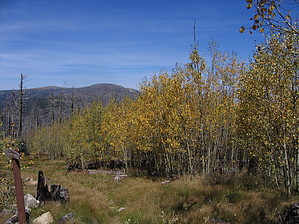
Redemption by fricknaley  3 years ago, I made my first trip to the Pinalenos and the Arcadia Trail. My wife and I loved the place. However, we got turned back about 1/2 mile from the peak of Heliograph due to monsoons. I promised to come back and complete my trip, and today I did. The place has changed from the fires, to be sure. Now a different trail from my first visit, I still find it exceptional and worthy of a visit. 3 years ago, I made my first trip to the Pinalenos and the Arcadia Trail. My wife and I loved the place. However, we got turned back about 1/2 mile from the peak of Heliograph due to monsoons. I promised to come back and complete my trip, and today I did. The place has changed from the fires, to be sure. Now a different trail from my first visit, I still find it exceptional and worthy of a visit.The trail takes off from the back of the picnic area just above the Arcadia Campground. In typical sky island fashion, it pulls no punches. You are climbing and soon enough switchbacking before you even know what hit you. Get used to it because this trail climbs steadily the whole way. This is little to no flat sections on this trail. As you climb up the canyon, it falls away to your right. Water runs in a small stream down below. You cross over the head of the stream and enter the canyon proper, with large views down the Pinalenos accompanying you much of the rest of the way. There is intermittent fire damage along the trail, at times heavy. The regrowth is considerable. Ferns, wildflowers galore, and higher-up aspens are making a strong push.
After two miles and considerable elevation gain, you reach a junction with Noon Creek Trail, which breaks off from to your right. You will continue straight for about 2 more miles of steady climbing. Periodically you will run up on the ridge cutting down the canyon, and you can look down forever (and see the Swift Trail far, far below). In the upper reaches, the fire damage is at times more evident. So is the regrowth. There is a very healthy lot of aspens coming in, and as of now, they are starting to turn. This upper stretch is pretty relentless climbing. At about 4 miles, you will reach a signed junction for the formal trail to Heliograph peak (328a). It is one mile to the peak. The trail breaks off to the left. This last stretch climbs just as steeply, if not more so. There are intermittent aspen stands and great views out towards Mt. Graham. There is some more burn evidence too. The trail occasionally gets a little thin here, but there are cairns and cutlines that are easy enough to follow. Near the top, you peak out in the most awesome little clearing with deep grass, tree trunks, and heavy aspens. This is probably the best part of the hike, an excellent place to hang out. You can see the watchtower to your left. The trail deadends at a gravel road. Hang a left at the sign and walk a couple hundred feet to the summit. There is an active lookout here (which they ask you not to climb) and great views. Very, very nice. You can head back the way you came, follow the gravel road around to your right and loop back to trail 328a, or take the gravel road all the way back to Shannon Campground and hike the Arcadia Trail back from there. Enjoy this hike; though it has certainly changed, it is still magnificent. I am thrilled that I kept my promise. Check out the Official Route and Triplogs. Note This is a more difficult hike. It would be unwise to attempt this without prior experience hiking. Leave No Trace and +Add a Triplog after your hike to support this local community. | ||||||||||||||||||||||||||||||||||||||||||||||||||||||||||||||||||||||||||||||||||||||||||||||||||||||||||