 Route Editor

| Guide | ♦ | 106 Triplogs | 0 Topics |
details | drive | permit | forecast | 🔥 route |
stats |
photos | triplogs | topics | location |
| 1.1k | 106 | 0 |
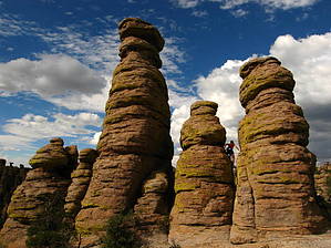
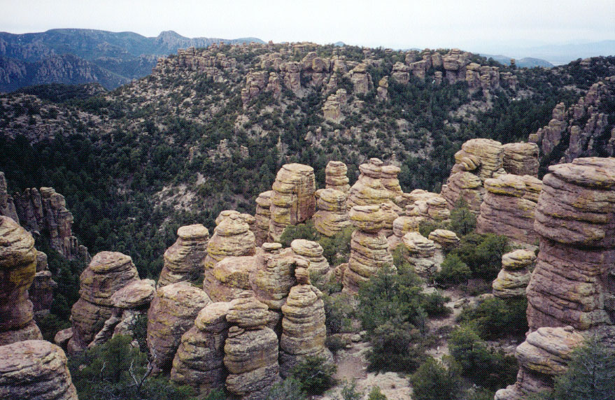
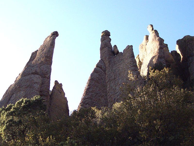
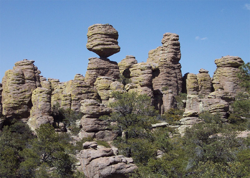
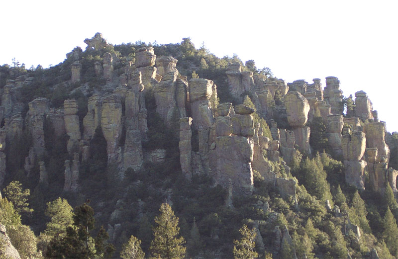
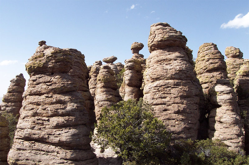
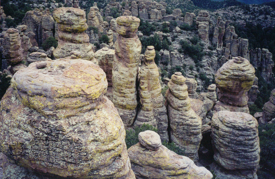
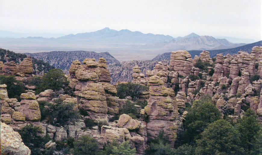
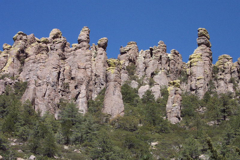
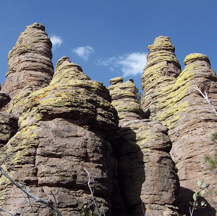
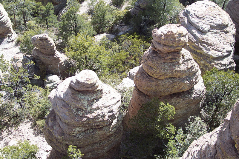
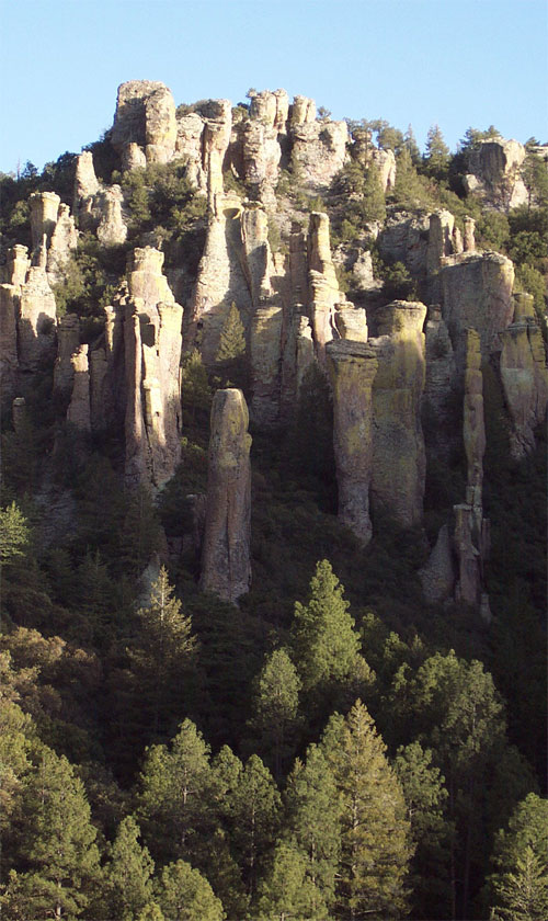
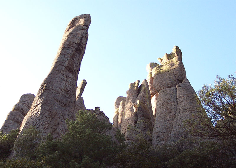
Out of this World! by brianb   The Chiricahua National Monument is the most wondrous and beautiful spot I know of in Southern Arizona. It may be one of Arizona's best-kept secrets because it's so out of the way. Don't let that discourage you! I would say, if you only do one hike in Southern Arizona, make it this one. The monument is an isolated spot on the map where, millions of years ago, volcanic activity left behind thousands of spires or "hoodoos" spread all over the landscape. These volcanic spires manifest themselves in a myriad of shapes and configurations, at times balancing impossibly on top of one another - jutting up straight out of the rocky ground in places and piercing through evergreen covered slopes in others. The Chiricahua National Monument is the most wondrous and beautiful spot I know of in Southern Arizona. It may be one of Arizona's best-kept secrets because it's so out of the way. Don't let that discourage you! I would say, if you only do one hike in Southern Arizona, make it this one. The monument is an isolated spot on the map where, millions of years ago, volcanic activity left behind thousands of spires or "hoodoos" spread all over the landscape. These volcanic spires manifest themselves in a myriad of shapes and configurations, at times balancing impossibly on top of one another - jutting up straight out of the rocky ground in places and piercing through evergreen covered slopes in others.The journey is a relatively easy trek with 1600 feet elevation gain spread over about 10 miles. The weather should be comfortable most of the year at 5400-7000 feet. The trail is extremely well maintained and well-marked throughout and is easy to follow. You'll get a free and very good trail map (with mileage and elevation) at the entrance to the monument. You can also customize your trip - taking combinations of trails that range (round-trip) from 7.3, 9.8, or 11.3 miles. Just make sure you include the Heart of Rocks Loop Trail in your plans - that's the "sweet spot" of the trip where the rock formations are the most spectacular and accessible. Practice your free-climbing skills on the rocks and capture unique and sometimes sweeping views.
From the Heart of Rocks Loop Trail, instead of turning back, continue along the trail that heads east into the park. (I forgot what all of the trials are called, and they're not named on the map, but you can plot the course easily with the map). Continue from the Heart of Rocks Loop trail junction for 1.0 miles to a one-way trail that splits off to something called "Inspiration Point". (I skipped that trail for lack of time). You'll travel through a forest of manzanita and pine, and capture awesome views of Cochise Head along the way. From the Inspiration Point junction, continue for another 1.2 miles. You'll drop into a beautiful forested area and emerge on the side of a forested valley with giant rock towers sprouting up on both sides. After this 1.2 mile stretch of trail, I followed the 0.8-mile trail segment straight ahead, but you could take a 2.3-mile loop around and through Echo Canyon making your trip 11.3 miles round-trip. (Not sure what that part's like - I'll find out next time...) After the 0.8 mile stretch through the valley, you end up at a trail junction that meets up with the end of the trail that comprises the 2.3-mile loop through Echo Canyon. Follow the trail sign that indicates that you're heading back to the Visitor Center. Continue down into the bottom of the valley along the 1.1-mile stretch that links back up with the Rhyolite Canyon Trail on which you started. It's another 1.5 miles from there back to the Visitor Center. Dogs Leashed dogs are only permitted on: Silver Spur Trail, Faraway Ranch Trail
Chiricahua NM NPS Details Easy Hikes: Short, smooth walks with little change in elevation BONITA CREEK LOOP LENGTH: 0.2 mile/0.3 km Pets Permitted ACCESS: Bonita Creek Parking Area TRAIL: This loop around the picnic area takes you along the intermittent Bonita Creek. Watch for Apache plume and prickly poppy flowers in spring and early summer. Arizona whitetail deer are frequently seen in the lower portion of Bonita Canyon. This is a good trail for grassland birds. BONITA CREEK TRAIL LENGTH: 0.5 mile/0.8 km Pets Permitted ACCESS: Bonita Creek or Faraway Ranch Parking Areas. TRAIL: Winding along Bonita Creek, usually dry, this trail connects the Bonita Creek and Faraway Ranch Picnic Areas. Look for migrating birds, deer, coatimundi and javelina. SILVER SPUR MEADOW TRAIL LENGTH: 1.2 miles/1.9km Pets Permitted ACCESS: Faraway Ranch, Visitor Center or Campground TRAIL: Beginning at the Faraway Ranch Picnic Area, this leisurely walk leads you through the Faraway Ranch Historic District to Stafford cabin, built in the 1880s. Next is Silver Spur Meadow, home for Civilian Conservation Camp NM-2-A, Company 828 during the 1930s. The fireplaces are remnants from the lodge of the Silver Spur Guest Ranch in business from 1948 to 1968. Stream crossings can be hazardous during spring snowmelt or the summer rains. VISITOR CENTER TO CAMPGROUND LENGTH: 0.4 mile/0.6 km Pets Permitted ACCESS: Visitor Center or near the campground groupsite TRAIL: Offering a safer alternative to walking along the road, look and listen for birds: dark-eyed juncos in winter, hummingbirds in summer and acorn wood-peckers year round. Stream crossings can be hazardous during spring snow melt or the summer rains. MASSAI POINT NATURE TRAIL LENGTH: 0.5 mile/0.8 km No Pets Watch for uneven footing, steps, and remember the higher elevation – 6,870 ft/2,094 m ACCESS: Massai Point TRAIL: This trail features grand vistas of the surrounding valleys and mountain ranges, a huge balanced rock and trail signs highlighting the natural history of the monument. The paved portion from the parking area to the exhibit building is wheelchair accessible. ECHO CANYON GROTTOES LENGTH: 1.0 mile/1.6 km round trip No Pets ACCESS: Echo Canyon Trailhead TRAIL: If you don’t have time to hike the full Echo Canyon Loop, consider this shorter option. It provides a great introduction to the wilderness area of the monument and the opportunity to walk among the rock formations. -------------------- Moderate Hikes: One to four hour hikes with elevation changes of 500 feet or less. Gravel trail surfaces. NATURAL BRIDGE TRAIL LENGTH: 4.8 miles/7.8 km round trip No Pets ACCESS: Small parking area along the Bonita Canyon Scenic Drive, 0.5 mile/ 0.8 km beyond the campground TRAIL: The least used trail in the monument climbs through oak and juniper woodlands to a ridge then drops into the Apache pine forest of Picket Park. It ends at an overlook for the small water-carved bridge located across the canyon. Return the same way. SUGARLOAF MOUNTAIN TRAIL LENGTH: 1.8 miles/2.8 km round trip No Pets ACCESS: Sugarloaf Mountain Trailhead TRAIL: Rising above the surrounding canyons, the summit of Sugarloaf Mountain at 7,310 ft/2,228 m is one of the highest points in the monument. The dark rock is dacite, evidence of a lava flow. Lightning activity is monitored from the CCC constructed fire lookout during summer. Return the same way. ECHO CANYON LOOP LENGTH: 3.3 miles/5.5 km No Pets The loop consists of Echo Canyon, Hailstone and Ed Riggs Trails. ACCESS: Echo Canyon Trailhead TRAIL: Most people prefer to hike the loop counter-clockwise since walking up the Ed Riggs Trail is less strenuous than the Echo Canyon Trail. The route winds through spectacular rock formations including the Grottoes and Wallstreet to the densely wooded Echo Park. Hailstone Trail is fairly level, and due to its southern exposure, hotter and dryer. Expect to see more desert plants: yuccas, agaves, prickly pear and hedgehog cactus. Ed Riggs Trail takes you back to the trailhead among large pine trees. Plan at least 2 hours for this hike. ECHO CANYON TO VISITOR CENTER LENGTH: 4.2 miles/6.8 km No Pets Echo Canyon, Upper Rhyolite Canyon and Lower Rhyolite Canyon Trails ACCESS: Echo Canyon Trailhead TRAIL: Mostly downhill through spectacular rock formations in Echo Canyon. White-throated swifts are common in the summer. One stream crossing on the Upper Rhyolite segment can be hazardous if runoff is significant. The last half of the hike is in shaded oak woodlands. Make sure you have transportation back to your vehicle or ride the hikers’ shuttle at 9:00 a.m. -------------------- Strenuous Hikes: Three to eight hour hikes with elevation changes of 500 to 1,000 feet / 150 to 300 meters. Gravel and rock trail surfaces. INSPIRATION POINT LENGTH: 5.4 miles/8.6 km round trip from Massai Point or 1 mile/1.6 km round trip from Big Balanced Rock Trail No Pets ACCESS: Massai Point or the junction of Mushroom Rock and Big Balanced Rock Trails TRAIL: This mostly level trail is a good place to slow down your heart rate after the trek up Mushroom Rock Trail. Excellent views of Cochise Head and Rhyolite Canyon make this a great rest stop. HEART OF ROCKS No Pets 1. Visitor Center to Heart of Rocks and Return This route consists of the Lower Rhyolite Canyon, Sarah Deming and Heart of Rocks Loop Trails. LENGTH: 7.3 miles/ 11.8 km round trip. ACCESS: Visitor Center Parking Lot TRAIL: Lower Rhyolite Canyon Trail begins as an easy level walk in the lower canyon forest, but soon starts climbing up Rhyolite Canyon. Sarah Deming Canyon gains 880 ft/268 m to reach the top of the ridge. Heart of Rocks Loop has many of the most unusual rock formations in the monument. Start the loop to the left and hike clockwise for the best views and easiest walking. Lots of rock steps make this a challenging loop, but it’s worth the effort. 2. Echo Canyon to Heart of Rocks and Return This route consists of the Ed Riggs, Mushroom Rock, Big Balanced Rock and Heart of Rocks Loop Trails. LENGTH: 7.3 miles/ 11.8 km ACCESS: Echo Canyon Trailhead TRAIL: An easier route to Heart of Rocks than starting from the Visitor Center with more views of the rock formations. Ed Riggs Trail drops you into the canyon while Mushroom Rock Trail climbs 610 ft/ 186 m up the other side. Big Balanced Rock Trail is along top of the ridge. Complete the Heart of Rocks and return, or continue with the Big Loop. 3. Echo Canyon or Massai Point, Heart of Rocks Loop to Visitor Center LENGTH: 7.3 miles/ 11.8 km Ed Riggs, Mushroom Rock, Big Balanced Rock, Heart of Rocks Loop, Sarah Deming and Lower Rhyolite Canyon Trails. ACCESS: Echo Canyon Parking Lot or Massai Point TRAIL: Make sure you have transportation back to your vehicle or ride the hikers’ shuttle at 8:30 a.m. Watch for changes in vegetation from the upper canyon areas to the lower canyon riparian areas. THE BIG LOOP For folks wanting to do everything, this route consists of the Echo Canyon, Upper Rhyolite Canyon, Sarah Deming, Heart of Rocks, Big Balanced Rock, Inspiration Point, Mushroom Rock and Ed Riggs trails. LENGTH: 9.5 miles/ 15.4 km No Pets ACCESS: Echo Canyon Trailhead TRAIL: Up and down across the canyons, the Big Loop combines the best of the wilderness scenery. Be sure to take snacks and drink plenty of water on this all day hike. -------------------- Hiking with Pets Pets are permitted in specific areas at Chiricahua National Monument. Dogs must be on a leash at all times and not left alone. You may only walk your dog on the lower canyon trails between the campground, visitor center, and entrance station on the Silver Spur Trail, Faraway Ranch Trail, and the campground. You may not bring your pets on any of the other park trails. This is for the safety of your dog and protection of the wildlife. Check out the Official Route and Triplogs. Leave No Trace and +Add a Triplog after your hike to support this local community. | ||||||||||||||||||||||||||||||||||||||||||||||||||||||||||||||||||||||||||||||||||||||||||||||||||||||||||||||||||||||||||||||||||||||||||||||||||||||||||||||||||||||||||||||||||||||||||||||||||||||||||||||||||||


