username
X
password
register
for free!
help
   🔥

Joe's Canyon Trail, AZ

Guide 24 Triplogs  1 Topic
  3.4 of 5 
Fav
Wish
1
details
drive
permit
forecast
🔥
route  
stats
photos
triplogs
topic
location
202 24 1
Statistics
tap icons for details
Difficulty 3 of 5
Distance One Way 3.25 miles
Trailhead Elevation 5,279 feet
Elevation Gain 1,460 feet
Accumulated Gain 1,525 feet
Kokopelli Seeds 8.33
 Backpack No
 Dogs not allowed
feature photo
Photos Viewed All MineFollowing
Will recalculate on button tap!
17  2023-05-06
Huachuca Mountains - AZT #1
RowdyandMe
5  2023-05-06
Huachuca Mountains - AZT #1
pseudalpine
8  2022-05-01
Montezuma - Miller - Border
DixieFlyer
17  2022-04-19
Montezuma Pass to border
markthurman53
2  2019-10-28
Huachuca Mountains - AZT #1
toddak
16  2018-07-13 DarthStiller
36  2016-04-02 DevilChild
13  2015-09-05
Montezuma Pass to Mexico
chumley
Page 1,  2
Author
author avatar Guides 16,883
Routes 17,298
Photos 24
Trips 1 map ( 6 miles )
Age 26 Male Gender
Location HAZ, TrailDEX
Associated Areas
list map done
Tucson Region
Historical Weather
Trailhead Forecast
Radar Map
Expand Map
Preferred Mar, Nov, Feb, Apr
Seasons   Autumn to Spring
Sun  5:16am - 7:23pm
Official Route
 
3 Alternative
 
 Water
Historic Fire Perimetersacres
🔥 2006 103 Fire9.1 mi*
🔥 1988 PEAK Fire46.4 mi*
🔥 View (All) - over Official Route 🔥
*perimeter length in miles


this is not teva canyon
by HAZ_Hikebot

Click to View Map

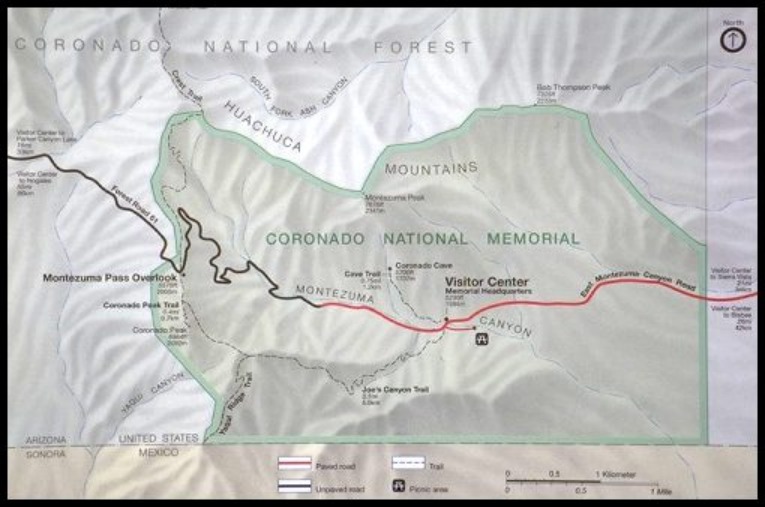
The trailhead is 500 feet west of the Visitor Center on Montezuma Canyon Road at the picnic area turnoff. The trail climbs about 1000 feet in the first mile with scenic views of Montezuma Canyon and the San Pedro River Valley. After reaching the saddle at the top of Smuggler's Ridge, the trail continues westward with southerly views deep into the grasslands of Sonora, Mexico. Passing along the northeastern side of Coronado Peak, it joins with the Coronado Peak Trail and Montezuma Pass parking area.

Check out the Official Route and Triplogs.

Leave No Trace and +Add a Triplog after your hike to support this local community.

2018-07-14 HAZ_Hikebot
  • 100 Classic Hikes - 2007
    area related
    100 Classic Hikes - 2007

One-Way Notice
This hike is listed as One-Way.

When hiking several trails on a single "hike", log it with a generic name that describes the hike. Then link the trails traveled, check out the example.
WARNING! Hiking and outdoor related sports can be dangerous. Be responsible and prepare for the trip. Study the area you are entering and plan accordingly. Dress for the current and unexpected weather changes. Take plenty of water. Never go alone. Make an itinerary with your plan(s), route(s), destination(s) and expected return time. Give your itinerary to trusted family and/or friends.

 Permit $$
no fees or permits reported

if incorrect tell us about it

Coronado Forest
MVUMs are rarely necessary to review unless mentioned in the description or directions
Coronado Motor Vehicle Use Maps (MVUMs)


 Directions
or
or
 Road


To hike
From Phoenix or Tucson take I-10 east and exit south on Hwy. 90 to Sierra Vista, then south on Hwy. 92 to S. Coronado Memorial Drive. (From Bisbee, take Hwy 92 west). Follow S. Coronado Memorial Drive 5 miles to the Visitor Center.

Approx 3 hours & 40 minutes from Phoenix
 90+° 8am - 6pm kills
helpcorrectionissue

end of page marker