Route Editor

| Guide | ♦ | 47 Triplogs | 7 Topics |
details | drive | no permit | forecast | 🔥 route |
stats |
photos | triplogs | topics | location |
| 555 | 47 | 7 |
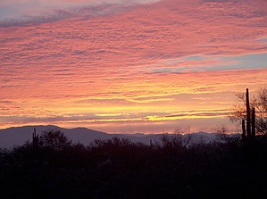
A Master Search by arizonaheat  Cactuscat and Arizonaheat were on the trail shortly before 7, our mission, Charlebois Loop II, from the Book (Carlson's - Hikers Guide to the Superstition Wilderness). Cactuscat and Arizonaheat were on the trail shortly before 7, our mission, Charlebois Loop II, from the Book (Carlson's - Hikers Guide to the Superstition Wilderness).The minute I got out of my truck my mistress immediately wrapped her fingers gently around my heart, pulling me toward Miners Needle via Dutchman Trail #104. As she pulled me deeper into her confines a serene sense of calm and tranquility overtook my being. With Miners Needle in sight, the sun began to rise behind some of her peaks. The sky was soon aglow with various colors of orange. As we passed in front of Miners Needle the sun cast its first rays, caressing the summit and the eye of the needle.
We continued up the Whiskey Spring Trail to the Red Tanks Trail #107, where we would pass La Barge Spring, which is located about 200 yards off the trail. We made our way to La Barge Spring which was a green oasis in the desert, with a decent flow of water. At the point where we left the trail to go to La Barge Spring, we came upon a couple, camping right on the trail. The female counterpart of the group, when pointing to the direction of the spring, exposed a thicket of jungle so dense, that it made our Bull Basin bushwhack look like nothing. Cactuscat and I both agreed, we had just seen unwhackable bush. From La Barge Spring we continued up the trail to where Red Tanks and Dutchman Trail intersect. From there we made our way up the Dutchman to Charlebois Spring, which has a good flow. On our way to Charlebois, we passed through a large camp of at least 12 people. We arrived at Charlebois around 10:30, distance to this point around 9 miles. We took about an hour break at Charlebois taking in the scenery and solitude, then it was back on the Dutchman for the return trip, which we would follow until it intersects the Bluff Spring Trail #235. The next stop was the magnificent, stately giant Saguaro that sports 57 arms and is listed in the National Registry. It is truly a sight to behold. We followed the Bluff Spring Trail back to the Peralta parking lot. We located the actual Bluff Spring on our way and found it to still had a flow. We then continued down the trail about 1/2 mile beyond where Bluff Springs and the Terrapin intersect. We decided these flat rocks were a good place to take a break, so we removed our daypacks and began to sit down. I looked across the way and there was a rock with the sun shining on it just right, and Peralta's signature carved into it. Way cool. From here we made our way the rest of the way down Bluff Springs, checking out the "trail" to Upper Barks, for a future adventure, and then back to the vehicle where it was time to celebrate the days' adventure with some beer. In summary, we found and checked out four different springs, saw some unwhackable bush, touched one of the largest if not the largest saguaros known to man with 57 arms, and found a rock with Peralta's signature etched in it. It was truly another great day with my mistress, Lady Superstition, she treated us well. The total hiking distance for this hike with side trips to the springs is 16+ miles. Check out the Official Route and Triplogs. Leave No Trace and +Add a Triplog after your hike to support this local community. | |||||||||||||||||||||||||||||||||||||||||||||||||||||||||||||||||||||||||||||||||||||||||||||||||||||||||||||