 Route Editor

| Guide | ♦ | 73 Triplogs | 3 Topics |
details | drive | permit | forecast | 🔥 route |
stats |
photos | triplogs | topics | location |
| 459 | 73 | 3 |
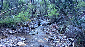
Nice Trail, Ugly Road by conform6073   2014 Update 2014 UpdateMileages have been updated to reflect the permanent road closure and trailhead now beginning 1 mile east of when this description was written. As part of the road closure, this road has been improved and is not nearly as "ugly" as originally described. This is a pleasant but otherwise undistinguished trail at the end of a really ugly road. Only the final four miles present a challenge, but negotiating those four can consume most of an hour... one could almost walk it faster. Most of the problems arise at stream crossings, of which there are five, where the grade in and out of the creekbed is steep. It's the sort of situation where you realize after you've committed to going that you don't remember if the differential is left or right of center and your passenger is hyperventilating and can't advise you in that regard. The right person in the right vehicle could drive this road in 2WD, but I was grateful to have 4L and not too proud to use it.
From this point, Gardner Trail climbs more steeply along an east-facing ridge. A few dead trees lie across the track, but the trail is otherwise well maintained with no signs of horses from here on. Pines appear, first pinons then ponderosa and frequent breaks in the hedge grant panoramic views down Gardner Canyon toward the Mustang Mountains. The trail tops the ridge in a couple of places allowing level walking for fairly long stretches. At 8,000 feet fire has created an open forest park with large ponderosas and a few white pines. 3.75 miles from the parking area Gardner Trail joins Super Trail at 8,400 feet, 0.7 miles, and 450 feet below Baldy Saddle. At 5.3 miles, the Gardner/Super/Crest Trail combination is the shortest route to Mt. Wrightson summit. Due to its location on the east side of the mountain, it receives good sun exposure through mid-afternoon, is shielded from prevailing westerly winds, and is essentially ignored by other hikers. Link it to Cave Canyon Trail, also accessed from Gardner Canyon and you have a 12.5-mile loop that should be a strenuous but pleasant day hike. But then there's that damn drive in and out. Coronado FS Details If you're looking for an off-the-beaten-path route to the summit of Mt. Wrightson and the Santa Rita Crest, this trail may be the one for you. When combined with the Cave Canyon Trail, it also provides an opportunity for a long, but manageable loop that also takes in those lofty heights. Gardner Trail ascends the eastern slopes of the Santa Ritas, passing through country that is virtually deserted when compared to popular Madera Canyon on the mountain's western slopes. This more remote area is similar in setting. The views, although quite different, are just as impressive. The trail begins at the end of Gardner Canyon Road and immediately begins traversing and switchbacking its way up the slopes of Mt. Wrightson. To the east, views stretch to the Chiricahuas of extreme eastern Arizona with the Whetstone, Mustang, and Huachuca Mountains floating in a sea of grass closer at hand. Below you, the forests of the Santa Ritas extend out into the grasslands bordering Cienega Creek. Gardner Trail ends at its junction with the Super Trail which you can follow north to junctions with the Crest and Old Baldy trails. The Crest Trail leads both to the summit of Mt. Wrightson and along the Santa Rita Crest to Florida Saddle where you can turn east again on Cave Canyon Trail to the Cave Gardner Cutoff Trail # 10. This loop is a total of 12 miles long if you don't visit the Mr. Wrightson summit, 14 miles and another hour if you do. This trail is entirely within the Mt. Wrightson Wilderness. Mechanized vehicles, including mountain bikes, are not permitted in Wilderness areas. Check out the Official Route and Triplogs. Leave No Trace and +Add a Triplog after your hike to support this local community. One-Way Notice This hike is listed as One-Way. When hiking several trails on a single "hike", log it with a generic name that describes the hike. Then link the trails traveled, check out the example. | ||||||||||||||||||||||||||||||||||||||||||||||||||||||||||||||||||||||||||||||||||||||||||||||||||||||||||||||||||||||||||||||||||||||||||||||||||||||||||||||||||||||||||||||||||||||||||||||||||||||


