Maverick Camp via 192B, AZ | HikeArizona
 This is likely a great time to hike this trail!  Check out "Preferred" months below, keep in mind this is an estimate.
  🔥

Maverick Camp via 192B, AZ

Guide 10 Triplogs Mine 0 0 Topics
 
4 of 5 
Fav
Wish
0
details
drive
no permit
forecast
🔥
route  
stats
photos
triplogs
topics
location
80 10 0
Statistics
tap icons for details
Difficulty 2.5 of 5
Route Finding 1 of 5
Distance Round Trip 6 miles
Trailhead Elevation 3,250 feet
Elevation Gain -650 feet
Accumulated Gain 1,090 feet
Avg Time Round Trip 3 hours
Kokopelli Seeds 11.45
 Backpack Possible - Not Popular
feature photo
Photos Viewed All MineFollowing
Inaugural Calculation on Button Tap!
25  2011-02-19
Hackberry Butte Summit 4230
Grasshopper
29  2008-12-31 Grasshopper
44  2007-10-27 kanode
7  2003-12-01 joebartels
Author
author avatar Guides 264
Routes 2,344
Photos 13,524
Trips 5,435 map ( 27,493 miles )
Age 53 Male Gender
Location
Associated Areas
list map done
Globe Region
Historical Weather
Trailhead Forecast
Radar Map
Expand Map
Preferred Mar, Nov, Feb, Jan → 9 AM
Seasons   Autumn to Spring
Sun  6:47am - 6:26pm
Official Route
 
3 Alternative
 
 Water
Historic Fire Perimetersacres
🔥 2021 Telegraph Fire266.7 mi**
🔥 2020 Sawtooth Fire24.7k
🔥 2019 Woodbury Fire123.8k
🔥 View (All) - over Official Route 🔥
*perimeter length in miles
**possible voids inflate figure
Nearby Area Water
[ View More! ]
Fauna  Nearby
Flora  Nearby
Geology  Nearby
Named place  Nearby
Culture  Nearby
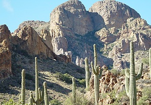
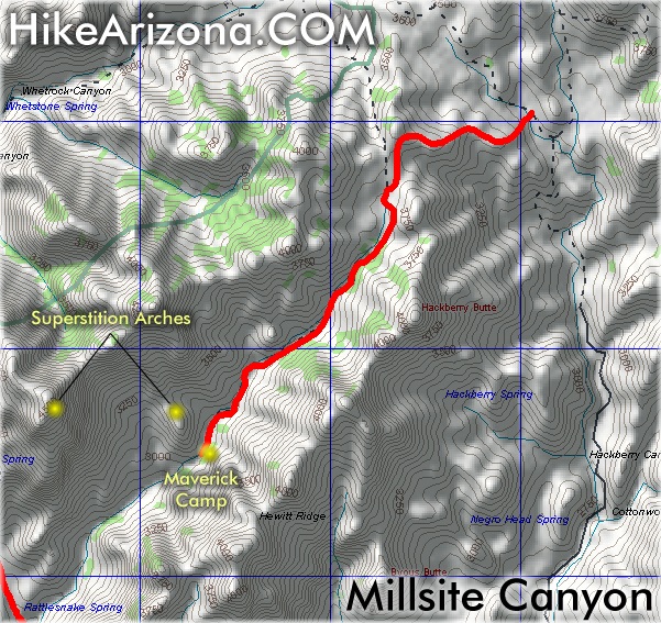
Wilderness beyond the boundary
by joebartels

 Likely In-Season!
Overview
Hike up FS 192 B about 500 feet in elevation over the northern tail end of Hewitt Ridge. Dropdown into Millsite Canyon about 700 feet in elevation to Maverick Camp. Return by the same route for data given on this page. Alternative return routes might include Hewitt Ridge or the opposing ridge back to start on an off-trail exploration.
Hike
No signs depict a trailhead or the start of this hike. Just jump on Forest Road 192 B and follow up over the northern subtle end of Hewitt Ridge. It's slightly steep in sections. Be careful not to slide backward on the loose pea-sized gravel. If you can get over the fact you're hiking a road you might enjoy the outstanding views of the rolling mountains.

It's about 1.1 miles to the old jeep route into Millsite Canyon. A flimsy fiberglass marker states no motorized travel beyond this point. However, Dr. Jones could eye analyze the fresh tracks and quickly conclude many break this simple rule.

The route is wide for a trail but narrow and twisted for a road. Soon you'll pass a not-so-old Chevy lodged in the declining creek. Although low key, the canyon is anything but boring. A late morning start will still put you in pockets of shade. Traveling down, positive thoughts churn out a bit easier. It's nothing to lose sleep over but this classifies as a very nice hike. Running water in the creek would be the element for greatness. A golden autumn ending may get your bid in regardless.

This hike has similarities to White Canyon & Quail Spring to Eagle Spring in what I call "Crisp Clean Desert Flora & Fauna". The colors are so true it's just delightful. Breezes come to life whistling through the bushes. Birds chirping among the mesquite scrub and Arizona Bluebirds darting about create a sensational atmosphere.

For the data represented on this page turn around in the area of Maverick Camp. It's likely you'll want to explore some on your own. Hunt down some rock art in the drainages or maybe take a side trip up to one of the Superstition Arches.

Check out the Official Route and Triplogs.

Leave No Trace and +Add a Triplog after your hike to support this local community.

2003-12-01 joebartels
  • guide related image
    guide related
WARNING! Hiking and outdoor related sports can be dangerous. Be responsible and prepare for the trip. Study the area you are entering and plan accordingly. Dress for the current and unexpected weather changes. Take plenty of water. Never go alone. Make an itinerary with your plan(s), route(s), destination(s) and expected return time. Give your itinerary to trusted family and/or friends.

 Permit $$
None


 Directions
or
or
 Road
FR / Jeep Road - Car possible when dry

To hike
Take US 60 east out of Apache Junction. A couple of miles past Florence Junction turn north onto Queen Valley Road and follow 1.6 miles. Turn right onto FS 357 (Hewlett Station Road) and follow about three miles to FS 172. Turn left onto FS 172 and follow to 172B/172A junction. Follow 172B for maybe 0.2 miles (I didn't check the odometer) to FS 192B. FS192B is not marked as of this writing. It's extremely rutted. I've driven the road in stock 4x4 Tacoma but I don't recommend it. Therefore this hike starts at the junction of 172B/192B.

11/12/2007 Kanode adds: I asked the Forest Service about the 4WD high clearance roads that access the Millsite Canyon trail and was told:
- the road to the north end, FR 192b, and is closed to motor vehicles.
- the roads in from the south (FR 1900 & 1935) are closed at Quail Spring.
helpcorrectionissue

end of page marker